Dorgeli night lights from space
Night Light of Dorgeli (Dagestan) from space (Russia) Src. Average luminocity for 10x10km area is 18.8% and for 50x50km: 6.4769%.
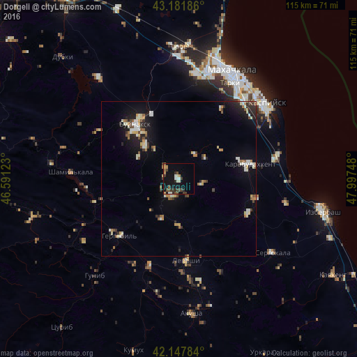
Analysis of Dorgeli night lights 2016
Square area 10x10 km:
 1.21%
1.21%90-99
3.48%80-89
1.52%70-79
1.52%60-69
1.36%50-59
3.18%40-49
2.73%30-39
6.06%20-29
3.18%10-19
18.33%0-9
57.42%Square area 50x50 km:
0.49%90-99
1.44%80-89
0.67%70-79
0.67%60-69
0.58%50-59
0.84%40-49
0.61%30-39
0.84%20-29
1.51%10-19
4.81%0-9
87.54%Clear (daylight) street map image can be seen on geolist.org.
Map coordinates:
43° 10' 54.7" North, 46° 35' 28.4" East
42° 40' 1.2" North, 47° 17' 39.7" East
42° 8' 52.2" North, 47° 59' 50.9" East
Some cities around Dorgeli sort by population:
• Buynaksk
22.1 km =13.7 mi,  319°
319°
• Karabudakhkent
22.8 km =14.2 mi,  78°
78°
• Nizhneye Kazanishche
15.3 km =9.5 mi,  314°
314°
• Gubden
24.8 km =15.4 mi,  116°
116°
• Levashi
26.4 km =16.4 mi,  175°
175°
• Nizhniy Dzhengutay
5.5 km =3.4 mi, 312°
• Verkhneye Kazanishche
14.9 km =9.3 mi,  300°
300°
• Gergebil’
26 km =16.2 mi,  225°
225°
564098 (p: 5,185)
Sources (retrieved 2019-11-25):
» Earth at Night: Flat Maps 2012, 2016