Ulluaya night lights from space
Night Light of Ulluaya (Dagestan) from space (Russia) Src. Average luminocity for 10x10km area is 10.0698% and for 50x50km: 2.5733%.
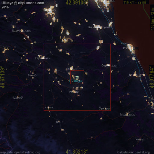
Analysis of Ulluaya night lights 2016
Square area 10x10 km:
 0%
0%90-99
0.79%80-89
1.75%70-79
1.59%60-69
0.63%50-59
1.27%40-49
1.59%30-39
2.7%20-29
3.33%10-19
1.9%0-9
84.44%Square area 50x50 km:
0.04%90-99
0.28%80-89
0.22%70-79
0.42%60-69
0.44%50-59
0.44%40-49
0.51%30-39
0.62%20-29
0.52%10-19
0.42%0-9
96.1%Clear (daylight) street map image can be seen on geolist.org.
Map coordinates:
42° 53' 27.8" North, 46° 40' 17" East
42° 22' 25.6" North, 47° 22' 28.2" East
41° 51' 7.8" North, 48° 4' 39.5" East
Some cities around Ulluaya sort by population:
• Sergokala
25.2 km =15.7 mi,  69°
69°
• Gubden
26.7 km =16.6 mi,  35°
35°
• Levashi
7.7 km =4.8 mi,  325°
325°
• Nizhniy Dzhengutay
37.8 km =23.5 mi,  343°
343°
• Khadzhalmakhi
16.6 km =10.3 mi,  288°
288°
• Urkarakh
31.5 km =19.6 mi,  138°
138°
• Dorgeli
33.3 km =20.7 mi,  348°
348°
• Gergebil’
29.2 km =18.1 mi,  299°
299°
479242 (p: 5,905)
Sources (retrieved 2019-11-25):
» Earth at Night: Flat Maps 2012, 2016