San Pedro de Ycuamandiyú night lights from space
Night Light of San Pedro de Ycuamandiyú (San Pedro) from space (Paraguay) Src. Average luminocity for 10x10km area is 15.2746% and for 50x50km: 1.3626%.
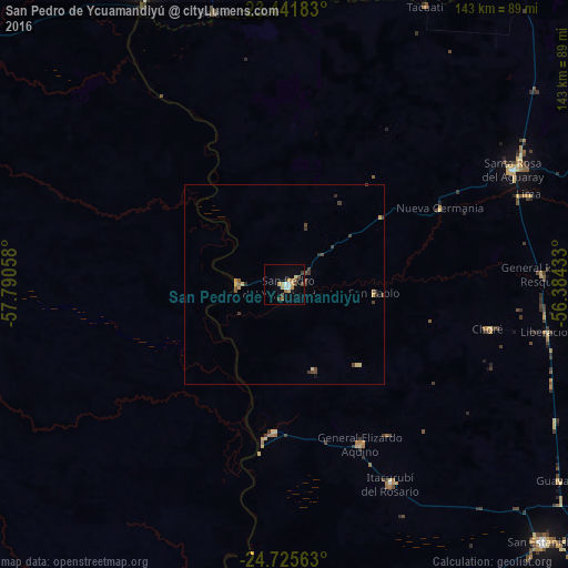
Analysis of San Pedro de Ycuamandiyú night lights 2016
Square area 10x10 km:
 1.7%
1.7%90-99
1.33%80-89
2.84%70-79
3.03%60-69
1.89%50-59
2.08%40-49
2.46%30-39
1.33%20-29
0.95%10-19
2.27%0-9
80.11%Square area 50x50 km:
0.07%90-99
0.05%80-89
0.3%70-79
0.23%60-69
0.09%50-59
0.2%40-49
0.44%30-39
0.4%20-29
0.13%10-19
0.14%0-9
97.95%Clear (daylight) street map image can be seen on geolist.org.
Map coordinates:
23° 26' 30.6" South, 57° 47' 26.1" West
24° 5' 7.2" South, 57° 5' 14.8" West
24° 43' 32.3" South, 56° 23' 3.6" West
Some cities around San Pedro de Ycuamandiyú sort by population:
• Limpio
126.7 km =78.7 mi,  198°
198°
• Villa Hayes
120.4 km =74.8 mi, 201°
• Concepción
83.9 km =52.1 mi,  335°
335°
• Horqueta
82.6 km =51.3 mi,  1°
1°
• Lima
65.5 km =40.7 mi,  69°
69°
• Benjamín Aceval
109.3 km =67.9 mi,  206°
206°
• Emboscada
121.3 km =75.4 mi,  192°
192°
• Puerto Rosario
40 km =24.9 mi, 188°
3437021 (p: 9,360)
Sources (retrieved 2019-11-25):
» Earth at Night: Flat Maps 2012, 2016