Benjamín Aceval night lights from space
Night Light of Benjamín Aceval (Presidente Hayes) from space (Paraguay) Src. Average luminocity for 10x10km area is 10.8352% and for 50x50km: 6.4075%.
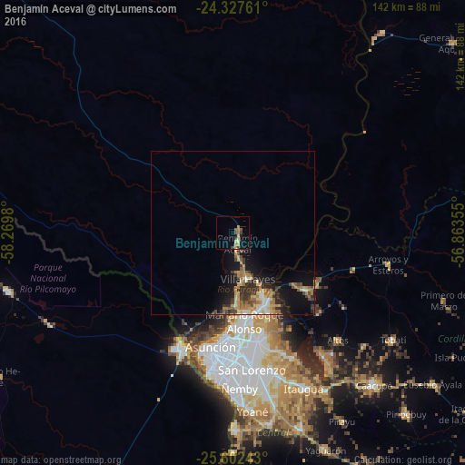
Analysis of Benjamín Aceval night lights 2016
Square area 10x10 km:
 0%
0%90-99
0.57%80-89
2.46%70-79
0.76%60-69
3.22%50-59
2.84%40-49
1.14%30-39
1.89%20-29
0.57%10-19
2.27%0-9
84.28%Square area 50x50 km:
0.43%90-99
0.73%80-89
1.02%70-79
1.04%60-69
1.44%50-59
0.76%40-49
0.96%30-39
1.22%20-29
1.5%10-19
4.4%0-9
86.5%Clear (daylight) street map image can be seen on geolist.org.
Map coordinates:
24° 19' 39.4" South, 58° 16' 11.3" West
24° 58' 0" South, 57° 34' 0" West
25° 36' 8.7" South, 56° 51' 48.8" West
Some cities around Benjamín Aceval sort by population:
• Asunción
36.5 km =22.7 mi,  192°
192°
• Fernando de la Mora
41.6 km =25.8 mi,  173°
173°
• Limpio
23.6 km =14.7 mi,  159°
159°
• Mariano Roque Alonso
27 km =16.8 mi, 172°
• Villa Hayes
14.7 km =9.1 mi, 162°
• Clorinda, AR
38.5 km =23.9 mi,  203°
203°
• Emboscada
29.9 km =18.6 mi,  133°
133°
• Nanawua
37.4 km =23.2 mi, 201°
3439348 (p: 7,751)
Sources (retrieved 2019-11-25):
» Earth at Night: Flat Maps 2012, 2016