San José night lights from space
Night Light of San José (Caaguazú) from space (Paraguay) Src. Average luminocity for 10x10km area is 6.256% and for 50x50km: 2.1682%.
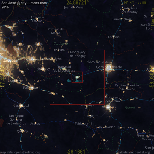
Analysis of San José night lights 2016
Square area 10x10 km:
 0.4%
0.4%90-99
0.4%80-89
1.59%70-79
1.98%60-69
0.4%50-59
0%40-49
1.59%30-39
0.79%20-29
0.79%10-19
0.79%0-9
91.27%Square area 50x50 km:
0.02%90-99
0.05%80-89
0.35%70-79
0.24%60-69
0.53%50-59
0.28%40-49
0.61%30-39
0.57%20-29
0.4%10-19
0.72%0-9
96.22%Clear (daylight) street map image can be seen on geolist.org.
Map coordinates:
24° 53' 50" South, 57° 26' 11.3" West
25° 31' 60" South, 56° 43' 60" West
26° 9' 58" South, 56° 1' 48.8" West
Some cities around San José sort by population:
• Coronel Oviedo
31 km =19.3 mi,  71°
71°
• Villarrica
38.3 km =23.8 mi,  128°
128°
• Caacupé
44.2 km =27.5 mi,  291°
291°
• Piribebuy
31.9 km =19.8 mi,  283°
283°
• Paraguarí
42.6 km =26.5 mi,  256°
256°
• Tobatí
46.4 km =28.8 mi,  310°
310°
• Eusebio Ayala
28.3 km =17.6 mi, 306°
• Yaguarón
55.3 km =34.4 mi,  266°
266°
3437074 (p: 5,117)
Sources (retrieved 2019-11-25):
» Earth at Night: Flat Maps 2012, 2016