Caacupé night lights from space
Night Light of Caacupé (Cordillera) from space (Paraguay) Src. Average luminocity for 10x10km area is 43.2579% and for 50x50km: 16.7627%.

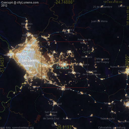
Analysis of Caacupé night lights 2016
Square area 10x10 km:
 4.37%
4.37%90-99
2.78%80-89
8.53%70-79
6.94%60-69
10.71%50-59
6.15%40-49
7.94%30-39
7.54%20-29
13.1%10-19
31.55%0-9
0.4%Square area 50x50 km:
0.55%90-99
0.71%80-89
2.01%70-79
2.68%60-69
4.54%50-59
2.69%40-49
3.92%30-39
3.96%20-29
5.45%10-19
11.47%0-9
62.03%Clear (daylight) street map image can be seen on geolist.org.
Map coordinates:
24° 44' 55.9" South, 57° 50' 43.1" West
25° 23' 8.7" South, 57° 8' 31.8" West
26° 1' 9.5" South, 56° 26' 20.6" West
Some cities around Caacupé sort by population:
• Itauguá
21.3 km =13.2 mi,  267°
267°
• Itá
25.9 km =16.1 mi,  240°
240°
• Areguá
25.7 km =16 mi,  288°
288°
• Piribebuy
13.4 km =8.3 mi,  131°
131°
• Tobatí
15.1 km =9.4 mi,  23°
23°
• Ypacarai
14.9 km =9.3 mi,  260°
260°
• Eusebio Ayala
18.2 km =11.3 mi,  88°
88°
• Yaguarón
24.1 km =15 mi,  215°
215°
3439320 (p: 21,696)
Sources (retrieved 2019-11-25):
» Earth at Night: Flat Maps 2012, 2016