Eusebio Ayala night lights from space
Night Light of Eusebio Ayala (Cordillera) from space (Paraguay) Src. Average luminocity for 10x10km area is 12.2698% and for 50x50km: 7.0536%.
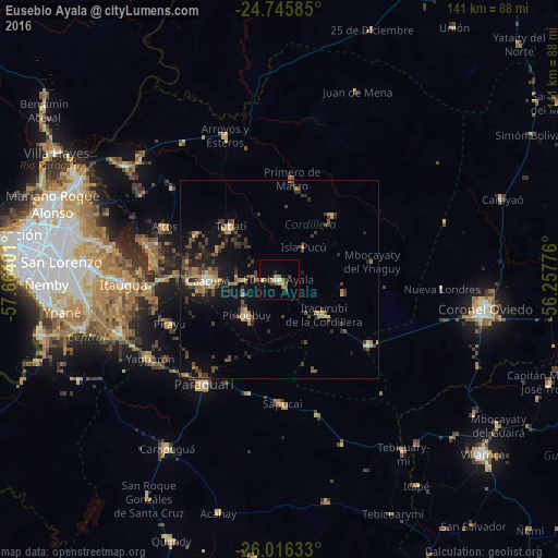
Analysis of Eusebio Ayala night lights 2016
Square area 10x10 km:
 0%
0%90-99
0.99%80-89
1.59%70-79
1.39%60-69
3.97%50-59
0.79%40-49
2.98%30-39
2.98%20-29
1.59%10-19
0.79%0-9
82.94%Square area 50x50 km:
0.26%90-99
0.19%80-89
0.93%70-79
0.96%60-69
1.32%50-59
0.79%40-49
1.87%30-39
2.28%20-29
1.9%10-19
5.08%0-9
84.43%Clear (daylight) street map image can be seen on geolist.org.
Map coordinates:
24° 44' 45.1" South, 57° 39' 50.4" West
25° 22' 57.9" South, 56° 57' 39.2" West
26° 0' 58.8" South, 56° 15' 27.9" West
Some cities around Eusebio Ayala sort by population:
• Itauguá
39.5 km =24.5 mi,  268°
268°
• Caacupé
18.2 km =11.3 mi, 268°
• Piribebuy
12.2 km =7.6 mi,  221°
221°
• Paraguarí
32.4 km =20.1 mi, 215°
• Tobatí
18.3 km =11.4 mi,  317°
317°
• Ypacarai
33.1 km =20.6 mi, 265°
• Yaguarón
38 km =23.6 mi,  238°
238°
• San José
28.3 km =17.6 mi,  126°
126°
3438123 (p: 8,253)
Sources (retrieved 2019-11-25):
» Earth at Night: Flat Maps 2012, 2016