Piribebuy night lights from space
Night Light of Piribebuy (Cordillera) from space (Paraguay) Src. Average luminocity for 10x10km area is 14.6052% and for 50x50km: 10.8586%.
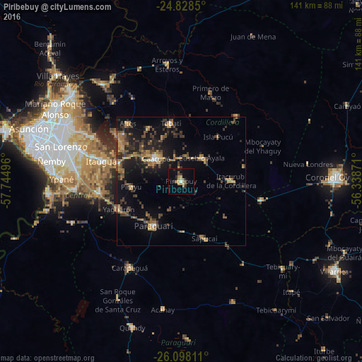
Analysis of Piribebuy night lights 2016
Square area 10x10 km:
 0.4%
0.4%90-99
0.4%80-89
3.17%70-79
0.99%60-69
5.36%50-59
0.79%40-49
1.98%30-39
2.18%20-29
2.18%10-19
5.95%0-9
76.59%Square area 50x50 km:
0.34%90-99
0.28%80-89
1.28%70-79
1.54%60-69
2.46%50-59
1.57%40-49
2.65%30-39
3.24%20-29
3.05%10-19
8.47%0-9
75.12%Clear (daylight) street map image can be seen on geolist.org.
Map coordinates:
24° 49' 42.6" South, 57° 44' 41.9" West
25° 27' 53.9" South, 57° 2' 30.6" West
26° 5' 53.2" South, 56° 20' 19.4" West
Some cities around Piribebuy sort by population:
• Itauguá
32.4 km =20.1 mi,  284°
284°
• Caacupé
13.4 km =8.3 mi,  311°
311°
• Paraguarí
20.3 km =12.6 mi,  211°
211°
• Tobatí
23 km =14.3 mi,  349°
349°
• Ypacarai
25.6 km =15.9 mi, 284°
• Eusebio Ayala
12.2 km =7.6 mi,  41°
41°
• Yaguarón
26.5 km =16.5 mi,  246°
246°
• San José
31.9 km =19.8 mi,  103°
103°
3437495 (p: 10,337)
Sources (retrieved 2019-11-25):
» Earth at Night: Flat Maps 2012, 2016