Repatriación night lights from space
Night Light of Repatriación (Caaguazú) from space (Paraguay) Src. Average luminocity for 10x10km area is 4.3333% and for 50x50km: 3.0885%.
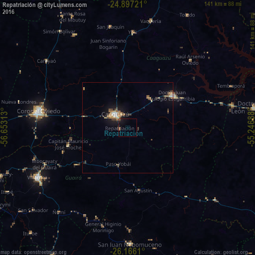
Analysis of Repatriación night lights 2016
Square area 10x10 km:
 0%
0%90-99
0%80-89
0%70-79
0%60-69
2.78%50-59
0%40-49
0%30-39
0.4%20-29
2.18%10-19
6.35%0-9
88.29%Square area 50x50 km:
0.17%90-99
0.3%80-89
0.34%70-79
0.45%60-69
0.97%50-59
0.18%40-49
0.53%30-39
0.57%20-29
0.5%10-19
2.35%0-9
93.65%Clear (daylight) street map image can be seen on geolist.org.
Map coordinates:
24° 53' 50" South, 56° 39' 11.3" West
25° 31' 60" South, 55° 57' 0" West
26° 9' 58" South, 55° 14' 48.8" West
Some cities around Repatriación sort by population:
• Caaguazú
9.6 km =6 mi,  316°
316°
• Coronel Oviedo
50.2 km =31.2 mi,  281°
281°
• Villarrica
54.2 km =33.7 mi,  243°
243°
• Caazapá
84.7 km =52.6 mi,  209°
209°
• Colonia General Alfredo Stroessner
30.8 km =19.1 mi,  52°
52°
• San Juan Nepomuceno
64.4 km =40 mi,  178°
178°
• Doctor Juan León Mallorquín
70.8 km =44 mi,  80°
80°
• San José
78.6 km =48.8 mi,  270°
270°
3437197 (p: 7,085)
Sources (retrieved 2019-11-25):
» Earth at Night: Flat Maps 2012, 2016