Lobão night lights from space
Night Light of Lobão (Aveiro) from space (Portugal) Src. Average luminocity for 10x10km area is 63.4048% and for 50x50km: 43.0121%.
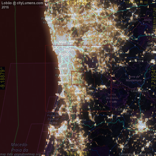
Analysis of Lobão night lights 2016
Square area 10x10 km:
100  2.38%
2.38%
90-99 7.14%
80-89 11.9%
70-79 20.92%
60-69 20.24%
50-59 13.27%
40-49 9.69%
30-39 6.97%
20-29 6.46%
10-19 1.02%
0-9 0%
2.38%90-99
7.14%80-89
11.9%70-79
20.92%60-69
20.24%50-59
13.27%40-49
9.69%30-39
6.97%20-29
6.46%10-19
1.02%0-9
0%Square area 50x50 km:
100 10.78%
90-99 7.87%
80-89 4.75%
70-79 5.7%
60-69 7.21%
50-59 5.82%
40-49 4.95%
30-39 6.07%
20-29 8.68%
10-19 10.18%
0-9 27.99%
10.78%90-99
7.87%80-89
4.75%70-79
5.7%60-69
7.21%50-59
5.82%40-49
4.95%30-39
6.07%20-29
8.68%10-19
10.18%0-9
27.99%Clear (daylight) street map image can be seen on geolist.org.
Map coordinates:
41° 30' 54.9" North, 9° 11' 19.6" West
40° 59' 11.9" North, 8° 29' 8.4" West
40° 27' 13.5" North, 7° 46' 57.1" West
Some cities around Lobão sort by population:
• Feira
8.3 km =5.2 mi,  215°
215°
• Lourosa
5.5 km =3.4 mi,  267°
267°
• São João de Ver
6.5 km =4 mi,  237°
237°
• Argoncilhe
6.2 km =3.9 mi,  314°
314°
• Fiães
3.4 km =2.1 mi,  284°
284°
• Arrifana
7.9 km =4.9 mi,  186°
186°
• Sandim
5.7 km =3.5 mi,  341°
341°
• Lamas
7 km =4.3 mi, 269°
2738277 (p: 6,049)
Sources (retrieved 2019-11-25):
» Earth at Night: Flat Maps 2012, 2016