Porto de Mós night lights from space
Night Light of Porto de Mós (Leiria) from space (Portugal) Src. Average luminocity for 10x10km area is 32.1234% and for 50x50km: 26.4604%.
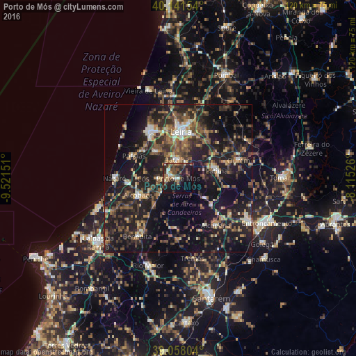
Analysis of Porto de Mós night lights 2016
Square area 10x10 km:
 2.11%
2.11%90-99
4.38%80-89
0.97%70-79
3.57%60-69
6.33%50-59
8.28%40-49
7.14%30-39
7.14%20-29
14.29%10-19
25.65%0-9
20.13%Square area 50x50 km:
1.61%90-99
2.9%80-89
2.06%70-79
2.76%60-69
4.21%50-59
5.46%40-49
5.13%30-39
6.25%20-29
11.91%10-19
27.32%0-9
30.39%Clear (daylight) street map image can be seen on geolist.org.
Map coordinates:
40° 8' 29.5" North, 9° 31' 17.4" West
39° 36' 6.9" North, 8° 49' 6.2" West
39° 3' 28.9" North, 8° 6' 54.9" West
Some cities around Porto de Mós sort by population:
• Monsanto
18 km =11.2 mi,  149°
149°
• Leiria
15.8 km =9.8 mi,  3°
3°
• Alcobaça
14.7 km =9.1 mi,  247°
247°
• Fátima
14.4 km =8.9 mi,  81°
81°
• Maceira
11.6 km =7.2 mi,  326°
326°
• Batalha
6.5 km =4 mi,  355°
355°
• Aljubarrota
10.3 km =6.4 mi, 247°
• Pataias
17 km =10.6 mi,  296°
296°
2264427 (p: 6,032)
Sources (retrieved 2019-11-25):
» Earth at Night: Flat Maps 2012, 2016