Fátima night lights from space
Night Light of Fátima (Santarém) from space (Portugal) Src. Average luminocity for 10x10km area is 34.8555% and for 50x50km: 26.3423%.
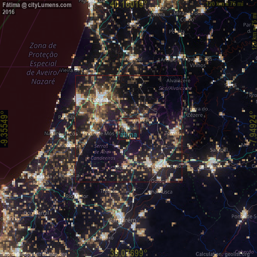
Analysis of Fátima night lights 2016
Square area 10x10 km:
 3.08%
3.08%90-99
4.06%80-89
4.06%70-79
5.03%60-69
4.38%50-59
6.01%40-49
6.98%30-39
5.19%20-29
17.05%10-19
39.61%0-9
4.55%Square area 50x50 km:
1.73%90-99
3.13%80-89
2.08%70-79
2.71%60-69
4.19%50-59
5.67%40-49
4.85%30-39
5.8%20-29
11.53%10-19
26.21%0-9
32.12%Clear (daylight) street map image can be seen on geolist.org.
Map coordinates:
40° 9' 36.7" North, 9° 21' 19.8" West
39° 37' 14.6" North, 8° 39' 8.5" West
39° 4' 37.2" North, 7° 56' 57.3" West
Some cities around Fátima sort by population:
• Monsanto
18.4 km =11.4 mi,  196°
196°
• Leiria
19 km =11.8 mi,  315°
315°
• Tomar
20.9 km =13 mi,  95°
95°
• Torres Novas
18.6 km =11.6 mi,  149°
149°
• Ourém
5.7 km =3.5 mi,  65°
65°
• Batalha
15.4 km =9.6 mi,  286°
286°
• Porto de Mós
14.4 km =8.9 mi,  261°
261°
• Caranguejeira
14.7 km =9.1 mi,  341°
341°
2268326 (p: 11,798)
Sources (retrieved 2019-11-25):
» Earth at Night: Flat Maps 2012, 2016