Peniche night lights from space
Night Light of Peniche (Leiria) from space (Portugal) Src. Average luminocity for 10x10km area is 30.2976% and for 50x50km: 12.5572%.
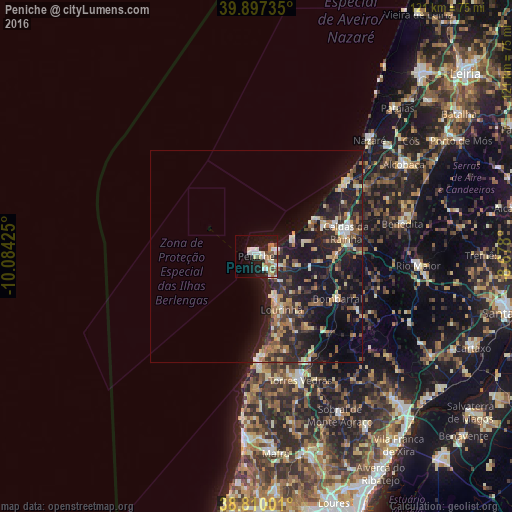
Analysis of Peniche night lights 2016
Square area 10x10 km:
 5.1%
5.1%90-99
6.29%80-89
4.25%70-79
4.25%60-69
4.08%50-59
3.74%40-49
1.87%30-39
1.87%20-29
4.08%10-19
28.06%0-9
36.39%Square area 50x50 km:
0.93%90-99
1.62%80-89
1.5%70-79
1.46%60-69
2.21%50-59
1.81%40-49
1.07%30-39
2.54%20-29
5.74%10-19
14.54%0-9
66.59%Clear (daylight) street map image can be seen on geolist.org.
Map coordinates:
39° 53' 50.5" North, 10° 5' 3.3" West
39° 21' 20.9" North, 9° 22' 52" West
38° 48' 36" North, 8° 40' 40.8" West
Some cities around Peniche sort by population:
• Caldas da Rainha
21.5 km =13.4 mi,  75°
75°
• Torres Vedras
31.3 km =19.4 mi,  160°
160°
• Óbidos
19.3 km =12 mi,  88°
88°
• Lourinhã
14 km =8.7 mi, 155°
• Atouguia da Baleia
5.1 km =3.2 mi,  112°
112°
• Silveira
27.2 km =16.9 mi,  176°
176°
• A dos Cunhados
23.7 km =14.7 mi, 162°
• Bombarral
21.6 km =13.4 mi,  117°
117°
2264923 (p: 15,662)
Sources (retrieved 2019-11-25):
» Earth at Night: Flat Maps 2012, 2016