A dos Cunhados night lights from space
Night Light of A dos Cunhados (Lisbon) from space (Portugal) Src. Average luminocity for 10x10km area is 44.3101% and for 50x50km: 23.9618%.
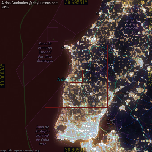
Analysis of A dos Cunhados night lights 2016
Square area 10x10 km:
 1.3%
1.3%90-99
4.87%80-89
3.9%70-79
6.49%60-69
11.85%50-59
7.31%40-49
8.28%30-39
19.81%20-29
29.71%10-19
6.49%0-9
0%Square area 50x50 km:
1.3%90-99
2.65%80-89
2.94%70-79
2.57%60-69
4.61%50-59
4.44%40-49
3.84%30-39
7.08%20-29
11.88%10-19
18.17%0-9
40.52%Clear (daylight) street map image can be seen on geolist.org.
Map coordinates:
39° 41' 43.8" North, 10° 0' 1.2" West
39° 9' 8.5" North, 9° 17' 49.9" West
38° 36' 18" North, 8° 35' 38.7" West
Some cities around A dos Cunhados sort by population:
• Torres Vedras
7.6 km =4.7 mi,  153°
153°
• Peniche
23.7 km =14.7 mi,  342°
342°
• Lourinhã
10 km =6.2 mi,  352°
352°
• Atouguia da Baleia
20.8 km =12.9 mi, 353°
• Ericeira
23.4 km =14.5 mi,  205°
205°
• Silveira
7.4 km =4.6 mi,  231°
231°
• Bombarral
17.5 km =10.9 mi,  43°
43°
• Ventosa
18.6 km =11.6 mi,  98°
98°
2272379 (p: 6,594)
Sources (retrieved 2019-11-25):
» Earth at Night: Flat Maps 2012, 2016