Lourinhã night lights from space
Night Light of Lourinhã (Lisbon) from space (Portugal) Src. Average luminocity for 10x10km area is 42.7041% and for 50x50km: 19.6275%.
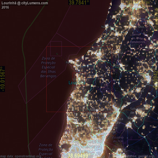
Analysis of Lourinhã night lights 2016
Square area 10x10 km:
 0.85%
0.85%90-99
5.44%80-89
6.8%70-79
6.63%60-69
14.29%50-59
6.63%40-49
2.89%30-39
13.78%20-29
17.86%10-19
21.6%0-9
3.23%Square area 50x50 km:
1.11%90-99
2.1%80-89
2.16%70-79
2.12%60-69
3.4%50-59
3.55%40-49
2.83%30-39
5.39%20-29
9.53%10-19
19.72%0-9
48.08%Clear (daylight) street map image can be seen on geolist.org.
Map coordinates:
39° 47' 2.8" North, 10° 0' 56.4" West
39° 14' 30" North, 9° 18' 45.1" West
38° 41' 42" North, 8° 36' 33.9" West
Some cities around Lourinhã sort by population:
• Caldas da Rainha
23.4 km =14.5 mi,  39°
39°
• Torres Vedras
17.4 km =10.8 mi,  164°
164°
• Peniche
14 km =8.7 mi,  335°
335°
• Óbidos
18.8 km =11.7 mi,  45°
45°
• Atouguia da Baleia
10.8 km =6.7 mi,  353°
353°
• Silveira
15.2 km =9.4 mi,  197°
197°
• A dos Cunhados
10 km =6.2 mi,  172°
172°
• Bombarral
13.6 km =8.5 mi,  77°
77°
2266961 (p: 9,196)
Sources (retrieved 2019-11-25):
» Earth at Night: Flat Maps 2012, 2016