Atouguia da Baleia night lights from space
Night Light of Atouguia da Baleia (Leiria) from space (Portugal) Src. Average luminocity for 10x10km area is 41.5714% and for 50x50km: 15.2585%.
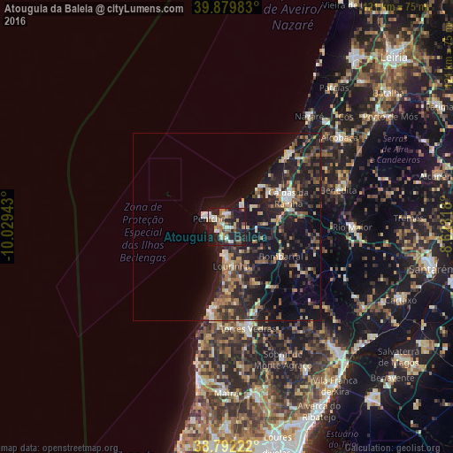
Analysis of Atouguia da Baleia night lights 2016
Square area 10x10 km:
 6.97%
6.97%90-99
5.78%80-89
4.42%70-79
5.44%60-69
6.12%50-59
6.46%40-49
4.08%30-39
6.12%20-29
19.39%10-19
34.35%0-9
0.85%Square area 50x50 km:
0.97%90-99
1.8%80-89
1.64%70-79
1.62%60-69
2.66%50-59
2.49%40-49
1.68%30-39
3.6%20-29
6.94%10-19
17.6%0-9
59%Clear (daylight) street map image can be seen on geolist.org.
Map coordinates:
39° 52' 47.4" North, 10° 1' 45.9" West
39° 20' 17.3" North, 9° 19' 34.7" West
38° 47' 32" North, 8° 37' 23.4" West
Some cities around Atouguia da Baleia sort by population:
• Caldas da Rainha
17.7 km =11 mi,  65°
65°
• Torres Vedras
28.1 km =17.5 mi,  168°
168°
• Peniche
5.1 km =3.2 mi,  292°
292°
• Óbidos
14.8 km =9.2 mi,  80°
80°
• Lourinhã
10.8 km =6.7 mi, 173°
• Silveira
25.4 km =15.8 mi,  187°
187°
• A dos Cunhados
20.8 km =12.9 mi, 173°
• Bombarral
16.5 km =10.3 mi,  118°
118°
2271354 (p: 8,313)
Sources (retrieved 2019-11-25):
» Earth at Night: Flat Maps 2012, 2016