Pedrouços night lights from space
Night Light of Pedrouços (Porto) from space (Portugal) Src. Average luminocity for 10x10km area is 99.6088% and for 50x50km: 51.9808%.
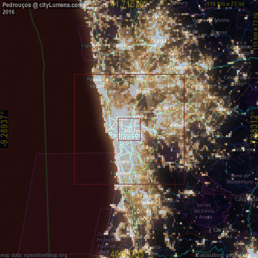
Analysis of Pedrouços night lights 2016
Square area 10x10 km:
 90.91%
90-99
8.44%80-89
0%70-79
0.65%60-69
0%50-59
0%40-49
0%30-39
0%20-29
0%10-19
0%0-9
0%Square area 50x50 km:
14.76%90-99
11.79%80-89
6.07%70-79
8.21%60-69
8.78%50-59
5.68%40-49
4.71%30-39
4.29%20-29
4.89%10-19
5.95%0-9
24.88%Clear (daylight) street map image can be seen on geolist.org.
Map coordinates:
41° 42' 56.8" North, 9° 17' 21.7" West
41° 11' 19.7" North, 8° 35' 10.5" West
40° 39' 27.1" North, 7° 52' 59.2" West
Some cities around Pedrouços sort by population:
• Porto
4.8 km =3 mi,  205°
205°
• Rio Tinto
2.5 km =1.6 mi,  116°
116°
• Ermesinde
4.1 km =2.5 mi,  41°
41°
• Águas Santas
2.5 km =1.6 mi,  19°
19°
• São Mamede de Infesta
2.1 km =1.3 mi,  279°
279°
• Fânzeres
5.3 km =3.3 mi, 116°
• Leça do Bailio
4.8 km =3 mi,  302°
302°
• Baguim do Monte
3.8 km =2.4 mi,  84°
84°
2736520 (p: 12,553)
Sources (retrieved 2019-11-25):
» Earth at Night: Flat Maps 2012, 2016