Fundão night lights from space
Night Light of Fundão (Castelo Branco) from space (Portugal) Src. Average luminocity for 10x10km area is 24.151% and for 50x50km: 7.1416%.
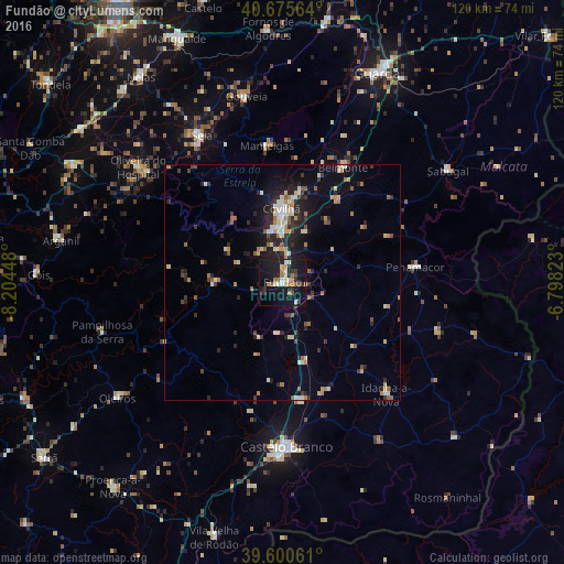
Analysis of Fundão night lights 2016
Square area 10x10 km:
 2.27%
2.27%90-99
2.6%80-89
3.25%70-79
2.11%60-69
4.71%50-59
3.73%40-49
1.3%30-39
2.44%20-29
5.36%10-19
39.29%0-9
32.95%Square area 50x50 km:
0.46%90-99
1.15%80-89
0.86%70-79
0.88%60-69
1.04%50-59
0.97%40-49
0.54%30-39
0.95%20-29
2.39%10-19
5.16%0-9
85.6%Clear (daylight) street map image can be seen on geolist.org.
Map coordinates:
40° 40' 32.3" North, 8° 12' 16.1" West
40° 8' 24.9" North, 7° 30' 4.9" West
39° 36' 2.2" North, 6° 47' 53.6" West
Some cities around Fundão sort by population:
• Castelo Branco
35.4 km =22 mi,  178°
178°
• Guarda
48.5 km =30.1 mi,  24°
24°
• Covilhã
15.7 km =9.8 mi,  358°
358°
• Tábua
51.1 km =31.8 mi,  298°
298°
• Seia
35.3 km =21.9 mi,  330°
330°
• São Romão
34.2 km =21.3 mi, 328°
• Oleiros
42.9 km =26.7 mi,  234°
234°
• Alcains
25.2 km =15.7 mi,  171°
171°
2739187 (p: 9,725)
Sources (retrieved 2019-11-25):
» Earth at Night: Flat Maps 2012, 2016