Covilhã night lights from space
Night Light of Covilhã (Castelo Branco) from space (Portugal) Src. Average luminocity for 10x10km area is 40.2993% and for 50x50km: 8.8925%.
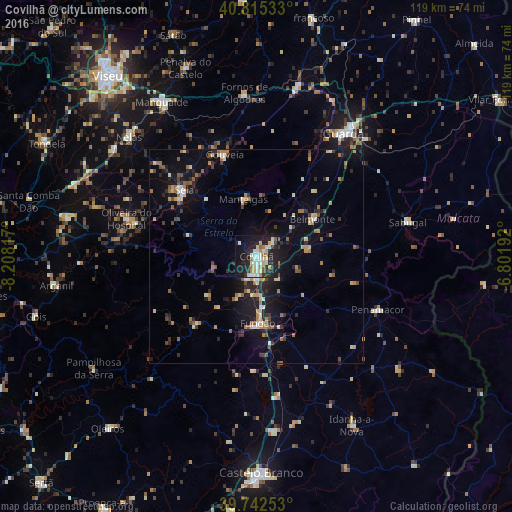
Analysis of Covilhã night lights 2016
Square area 10x10 km:
 7.65%
7.65%90-99
10.2%80-89
5.44%70-79
4.25%60-69
3.57%50-59
2.89%40-49
0.51%30-39
3.4%20-29
18.71%10-19
33.33%0-9
10.03%Square area 50x50 km:
0.59%90-99
1.28%80-89
0.9%70-79
1.16%60-69
1.4%50-59
1.16%40-49
0.72%30-39
1.2%20-29
2.86%10-19
7.2%0-9
81.54%Clear (daylight) street map image can be seen on geolist.org.
Map coordinates:
40° 48' 55.2" North, 8° 12' 29.4" West
40° 16' 51.8" North, 7° 30' 18.1" West
39° 44' 33.1" North, 6° 48' 6.9" West
Some cities around Covilhã sort by population:
• Guarda
35 km =21.7 mi,  35°
35°
• Sequeira
38.4 km =23.9 mi, 37°
• Fundão
15.7 km =9.8 mi,  178°
178°
• Mangualde
42 km =26.1 mi,  328°
328°
• Seia
22.8 km =14.2 mi,  310°
310°
• São Romão
22.2 km =13.8 mi, 306°
• Carregal do Sal
45.2 km =28.1 mi,  291°
291°
• Alcains
40.8 km =25.4 mi,  174°
174°
2740313 (p: 17,610)
Sources (retrieved 2019-11-25):
» Earth at Night: Flat Maps 2012, 2016