Oleiros night lights from space
Night Light of Oleiros (Castelo Branco) from space (Portugal) Src. Average luminocity for 10x10km area is 6.1514% and for 50x50km: 3.3826%.
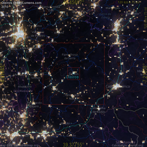
Analysis of Oleiros night lights 2016
Square area 10x10 km:
 0.34%
0.34%90-99
1.7%80-89
0.68%70-79
1.02%60-69
1.02%50-59
0.85%40-49
0.51%30-39
0%20-29
1.36%10-19
0%0-9
92.52%Square area 50x50 km:
0.1%90-99
0.55%80-89
0.34%70-79
0.34%60-69
0.41%50-59
0.51%40-49
0.63%30-39
0.55%20-29
1.19%10-19
0.49%0-9
94.89%Clear (daylight) street map image can be seen on geolist.org.
Map coordinates:
40° 27' 21.9" North, 8° 37' 0.6" West
39° 55' 8.1" North, 7° 54' 49.3" West
39° 22' 39.2" North, 7° 12' 38.1" West
Some cities around Oleiros sort by population:
• Castelo Branco
37.7 km =23.4 mi,  106°
106°
• Tábua
50.2 km =31.2 mi,  348°
348°
• Lousã
36.1 km =22.4 mi,  307°
307°
• Fundão
42.9 km =26.7 mi,  54°
54°
• Miranda do Corvo
40.6 km =25.2 mi,  298°
298°
• Sertã
20.3 km =12.6 mi,  230°
230°
• Poiares
43.6 km =27.1 mi,  317°
317°
• Alcains
39 km =24.2 mi,  90°
90°
2265450 (p: 5,721)
Sources (retrieved 2019-11-25):
» Earth at Night: Flat Maps 2012, 2016