Tábua night lights from space
Night Light of Tábua (Coimbra) from space (Portugal) Src. Average luminocity for 10x10km area is 16.3639% and for 50x50km: 8.6818%.
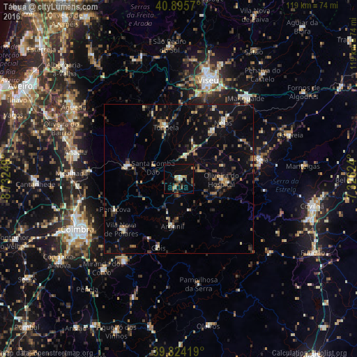
Analysis of Tábua night lights 2016
Square area 10x10 km:
 0.68%
0.68%90-99
2.72%80-89
0.68%70-79
2.21%60-69
3.06%50-59
3.06%40-49
2.04%30-39
2.38%20-29
1.02%10-19
12.93%0-9
69.22%Square area 50x50 km:
0.34%90-99
0.88%80-89
0.73%70-79
0.69%60-69
1.14%50-59
1.37%40-49
1.52%30-39
2.14%20-29
2.54%10-19
6.32%0-9
82.32%Clear (daylight) street map image can be seen on geolist.org.
Map coordinates:
40° 53' 44.5" North, 8° 43' 57" West
40° 21' 43.5" North, 8° 1' 45.7" West
39° 49' 27.1" North, 7° 19' 34.5" West
Some cities around Tábua sort by population:
• Viseu
34.7 km =21.6 mi,  16°
16°
• Santa Comba Dão
9.6 km =6 mi,  295°
295°
• Lousã
33.1 km =20.6 mi,  214°
214°
• Tondela
17.8 km =11.1 mi,  345°
345°
• Seia
27.8 km =17.3 mi,  77°
77°
• São Romão
27 km =16.8 mi, 80°
• Carregal do Sal
8.3 km =5.2 mi, 17°
• Poiares
25.7 km =16 mi,  228°
228°
2733720 (p: 12,071)
Sources (retrieved 2019-11-25):
» Earth at Night: Flat Maps 2012, 2016