São Romão night lights from space
Night Light of São Romão (Guarda) from space (Portugal) Src. Average luminocity for 10x10km area is 22.1003% and for 50x50km: 11.6765%.
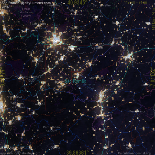
Analysis of São Romão night lights 2016
Square area 10x10 km:
 2.38%
2.38%90-99
2.38%80-89
1.7%70-79
2.72%60-69
3.23%50-59
4.25%40-49
3.23%30-39
3.06%20-29
5.95%10-19
23.47%0-9
47.62%Square area 50x50 km:
0.78%90-99
1.51%80-89
1.04%70-79
1.09%60-69
1.56%50-59
1.86%40-49
1.5%30-39
2.13%20-29
3.92%10-19
11.72%0-9
72.9%Clear (daylight) street map image can be seen on geolist.org.
Map coordinates:
40° 56' 4.2" North, 8° 25' 4" West
40° 24' 4.2" North, 7° 42' 52.7" West
39° 51' 49" North, 7° 0' 41.5" West
Some cities around São Romão sort by population:
• Viseu
33.3 km =20.7 mi,  330°
330°
• Covilhã
22.2 km =13.8 mi,  126°
126°
• Tábua
27 km =16.8 mi,  260°
260°
• Rio de Loba
32.5 km =20.2 mi, 334°
• Mangualde
22.9 km =14.2 mi,  350°
350°
• Tondela
33.5 km =20.8 mi,  292°
292°
• Seia
1.6 km =1 mi,  18°
18°
• Carregal do Sal
24.4 km =15.2 mi,  278°
278°
2734346 (p: 6,500)
Sources (retrieved 2019-11-25):
» Earth at Night: Flat Maps 2012, 2016