Alfena night lights from space
Night Light of Alfena (Porto) from space (Portugal) Src. Average luminocity for 10x10km area is 79.2825% and for 50x50km: 60.2998%.
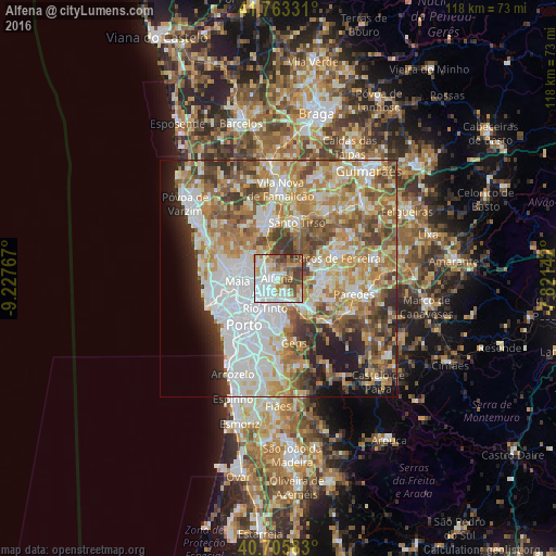
Analysis of Alfena night lights 2016
Square area 10x10 km:
 31.17%
90-99
18.83%80-89
5.84%70-79
9.58%60-69
11.53%50-59
6.49%40-49
11.69%30-39
4.87%20-29
0%10-19
0%0-9
0%Square area 50x50 km:
15.07%90-99
13.05%80-89
7.72%70-79
9.79%60-69
11.12%50-59
8.05%40-49
6.79%30-39
5.59%20-29
5.63%10-19
5.77%0-9
11.41%Clear (daylight) street map image can be seen on geolist.org.
Map coordinates:
41° 45' 47.9" North, 9° 13' 39.6" West
41° 14' 12.2" North, 8° 31' 28.3" West
40° 42' 21" North, 7° 49' 17.1" West
Some cities around Alfena sort by population:
• Rio Tinto
7.1 km =4.4 mi,  204°
204°
• Ermesinde
3.3 km =2.1 mi,  226°
226°
• Águas Santas
5.2 km =3.2 mi,  235°
235°
• Valongo
5.7 km =3.5 mi,  157°
157°
• Baguim do Monte
5.2 km =3.2 mi, 195°
• Pedrouços
7.4 km =4.6 mi,  224°
224°
• São Romão do Coronado
6.3 km =3.9 mi,  329°
329°
• Sobrado
6.5 km =4 mi,  116°
116°
2743095 (p: 15,211)
Sources (retrieved 2019-11-25):
» Earth at Night: Flat Maps 2012, 2016