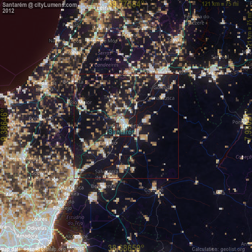
Santarém night lights from space
Night Light of Santarém from space (Portugal) Src. Average luminocity for 10x10km area is 42.432% and for 50x50km: 18.3991%.
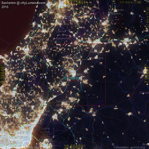
Analysis of Santarém night lights 2016
Square area 10x10 km:
 8.33%
8.33%90-99
11.05%80-89
3.23%70-79
4.42%60-69
5.1%50-59
2.89%40-49
2.55%30-39
2.55%20-29
17.86%10-19
42.01%0-9
0%Square area 50x50 km:
1.1%90-99
2.5%80-89
2.18%70-79
1.94%60-69
2.27%50-59
2.48%40-49
2.62%30-39
2.6%20-29
6.68%10-19
24.2%0-9
51.42%Clear (daylight) street map image can be seen on geolist.org.
Map coordinates:
39° 46' 33" North, 9° 23' 11.3" West
39° 13' 60" North, 8° 40' 60" West
38° 41' 11.7" North, 7° 58' 48.8" West
Some cities around Santarém sort by population:
• Almeirim
5.6 km =3.5 mi,  119°
119°
• Cartaxo
12.1 km =7.5 mi,  227°
227°
• Alpiarça
9.1 km =5.7 mi,  73°
73°
• Azambuja
24.1 km =15 mi,  221°
221°
• Fazendas de Almeirim
11.7 km =7.3 mi, 123°
• Marinhais
20.7 km =12.9 mi,  184°
184°
• Salvaterra de Magos
24.7 km =15.3 mi,  202°
202°
• Alcanede
23.5 km =14.6 mi,  329°
329°
2263480 (p: 29,385)
Sources (retrieved 2019-11-25):
» Earth at Night: Flat Maps 2012, 2016