Ţūbās night lights from space
Night Light of Ţūbās (West Bank) from space (Palestinian Territory) Src. Average luminocity for 10x10km area is 32.1538% and for 50x50km: 35.5966%.
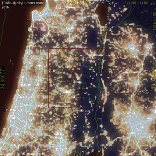
Analysis of Ţūbās night lights 2016
Square area 10x10 km:
 0.37%
0.37%90-99
2.01%80-89
4.4%70-79
9.16%60-69
3.85%50-59
4.21%40-49
7.33%30-39
4.21%20-29
15.93%10-19
33.52%0-9
15.02%Square area 50x50 km:
1.71%90-99
2.71%80-89
7.14%70-79
6.86%60-69
4.84%50-59
5.7%40-49
9.91%30-39
9.76%20-29
12.78%10-19
14.79%0-9
23.79%Clear (daylight) street map image can be seen on geolist.org.
Map coordinates:
32° 54' 47.3" North, 34° 40' 0.4" East
32° 19' 15.3" North, 35° 22' 11.6" East
31° 43' 29.2" North, 36° 4' 22.9" East
Some cities around Ţūbās sort by population:
• Nablus
15.5 km =9.6 mi,  224°
224°
• Qabāţīyah
13 km =8.1 mi,  319°
319°
• Balāţah
14.5 km =9 mi,  213°
213°
• Ţammūn
4.4 km =2.7 mi,  162°
162°
• Jaba‘
14 km =8.7 mi,  271°
271°
• ‘Aşīrah ash Shamālīyah
12.4 km =7.7 mi,  231°
231°
• Maythalūn
9.5 km =5.9 mi,  288°
288°
• Dayr Abū Ḑa‘īf
15 km =9.3 mi,  357°
357°
281581 (p: 15,591)
Sources (retrieved 2019-11-25):
» Earth at Night: Flat Maps 2012, 2016