Balāţah night lights from space
Night Light of Balāţah (West Bank) from space (Palestinian Territory) Src. Average luminocity for 10x10km area is 71.0892% and for 50x50km: 37.7106%.
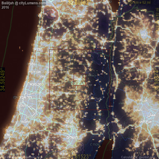
Analysis of Balāţah night lights 2016
Square area 10x10 km:
 10.84%
90-99
11.89%80-89
19.93%70-79
13.81%60-69
9.62%50-59
16.43%40-49
10.14%30-39
2.62%20-29
4.72%10-19
0%0-9
0%Square area 50x50 km:
2.04%90-99
3.06%80-89
6.89%70-79
8.41%60-69
5.49%50-59
7.13%40-49
10.55%30-39
10%20-29
11.75%10-19
8.46%0-9
26.22%Clear (daylight) street map image can be seen on geolist.org.
Map coordinates:
32° 48' 18.1" North, 34° 34' 57" East
32° 12' 43.5" North, 35° 17' 8.2" East
31° 36' 54.8" North, 35° 59' 19.5" East
Some cities around Balāţah sort by population:
• Nablus
3.1 km =1.9 mi,  288°
288°
• Bayt Fūrīk
6.1 km =3.8 mi,  129°
129°
• Baytā al Fawqā
7.7 km =4.8 mi,  178°
178°
• ‘Aqrabā
11.2 km =7 mi,  149°
149°
• ‘Aşīrah ash Shamālīyah
4.7 km =2.9 mi,  338°
338°
• Jammā‘īn
11.8 km =7.3 mi,  220°
220°
• Ḩuwwārah
7.2 km =4.5 mi,  202°
202°
• ‘Awartā
5.7 km =3.5 mi, 181°
284446 (p: 17,146)
Sources (retrieved 2019-11-25):
» Earth at Night: Flat Maps 2012, 2016