Ţammūn night lights from space
Night Light of Ţammūn (West Bank) from space (Palestinian Territory) Src. Average luminocity for 10x10km area is 25.7875% and for 50x50km: 33.4643%.
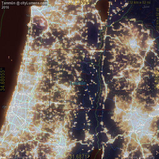
Analysis of Ţammūn night lights 2016
Square area 10x10 km:
 0.18%
0.18%90-99
1.47%80-89
2.01%70-79
6.59%60-69
3.66%50-59
3.11%40-49
4.76%30-39
6.96%20-29
16.12%10-19
24.91%0-9
30.22%Square area 50x50 km:
1.38%90-99
2.34%80-89
6.6%70-79
6.67%60-69
4.59%50-59
5.18%40-49
9.4%30-39
9.08%20-29
12.08%10-19
15.47%0-9
27.21%Clear (daylight) street map image can be seen on geolist.org.
Map coordinates:
32° 52' 33.4" North, 34° 40' 50" East
32° 17' 0.5" North, 35° 23' 1.2" East
31° 41' 13.6" North, 36° 5' 12.5" East
Some cities around Ţammūn sort by population:
• Nablus
14 km =8.7 mi,  240°
240°
• Balāţah
12.2 km =7.6 mi,  229°
229°
• Ţūbās
4.4 km =2.7 mi,  342°
342°
• Bayt Fūrīk
12.7 km =7.9 mi,  200°
200°
• Jaba‘
15.9 km =9.9 mi,  286°
286°
• ‘Aşīrah ash Shamālīyah
11.5 km =7.1 mi,  251°
251°
• Maythalūn
12.5 km =7.8 mi,  304°
304°
• ‘Awartā
16.5 km =10.3 mi,  214°
214°
281657 (p: 10,119)
Sources (retrieved 2019-11-25):
» Earth at Night: Flat Maps 2012, 2016