Sabana Seca night lights from space
Night Light of Sabana Seca (Toa Baja) from space (Puerto Rico) Src. Average luminocity for 10x10km area is 86.2541% and for 50x50km: 39.4608%.
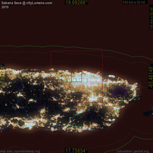
Analysis of Sabana Seca night lights 2016
Square area 10x10 km:
 48.35%
90-99
21.28%80-89
8.47%70-79
3.1%60-69
2.48%50-59
2.69%40-49
3.31%30-39
8.06%20-29
2.27%10-19
0%0-9
0%Square area 50x50 km:
10.71%90-99
6.24%80-89
4.72%70-79
5.64%60-69
7.15%50-59
4.94%40-49
5.04%30-39
5.13%20-29
6.87%10-19
8.31%0-9
35.27%Clear (daylight) street map image can be seen on geolist.org.
Map coordinates:
19° 5' 33.6" North, 66° 53' 15.9" West
18° 25' 36.8" North, 66° 11' 4.6" West
17° 45' 30.7" North, 65° 28' 53.4" West
Some cities around Sabana Seca sort by population:
• Bayamón
4.4 km =2.7 mi,  135°
135°
• Levittown
2.6 km =1.6 mi,  7°
7°
• Cataño
7.2 km =4.5 mi,  77°
77°
• Candelaria
3.6 km =2.2 mi,  225°
225°
• Pájaros
7.3 km =4.5 mi,  207°
207°
• Campanilla
5.5 km =3.4 mi,  263°
263°
• Candelaria Arenas
3.6 km =2.2 mi,  252°
252°
• Ingenio
4.7 km =2.9 mi,  291°
291°
4568023 (p: 6,247)
Sources (retrieved 2019-11-25):
» Earth at Night: Flat Maps 2012, 2016