Sulejówek night lights from space
Night Light of Sulejówek (Mazovia) from space (Poland) Src. Average luminocity for 10x10km area is 43.2421% and for 50x50km: 32.5589%.
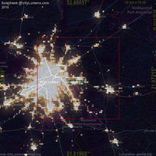
Analysis of Sulejówek night lights 2016
Square area 10x10 km:
 5.69%
5.69%90-99
8.2%80-89
5.69%70-79
2.91%60-69
4.1%50-59
10.19%40-49
6.35%30-39
10.58%20-29
19.97%10-19
21.43%0-9
4.89%Square area 50x50 km:
11.59%90-99
6.66%80-89
2.86%70-79
2.83%60-69
3.05%50-59
2.91%40-49
3.14%30-39
3.68%20-29
6.12%10-19
10.69%0-9
46.46%Clear (daylight) street map image can be seen on geolist.org.
Map coordinates:
52° 40' 50.1" North, 20° 33' 57.2" East
52° 15' 8" North, 21° 16' 8.5" East
51° 49' 10.8" North, 21° 58' 19.7" East
Some cities around Sulejówek sort by population:
• Praga Południe
12.5 km =7.8 mi,  265°
265°
• Wawer
8.8 km =5.5 mi,  225°
225°
• Wołomin
9.9 km =6.2 mi,  349°
349°
• Ząbki
12 km =7.5 mi,  292°
292°
• Rembertów
7.2 km =4.5 mi,  277°
277°
• Wesoła
3.1 km =1.9 mi, 274°
• Kobyłka
10.9 km =6.8 mi,  332°
332°
• Zielonka
9.4 km =5.8 mi,  307°
307°
757809 (p: 18,414)
Sources (retrieved 2019-11-25):
» Earth at Night: Flat Maps 2012, 2016