Zielonka night lights from space
Night Light of Zielonka (Mazovia) from space (Poland) Src. Average luminocity for 10x10km area is 65.2247% and for 50x50km: 37.0697%.
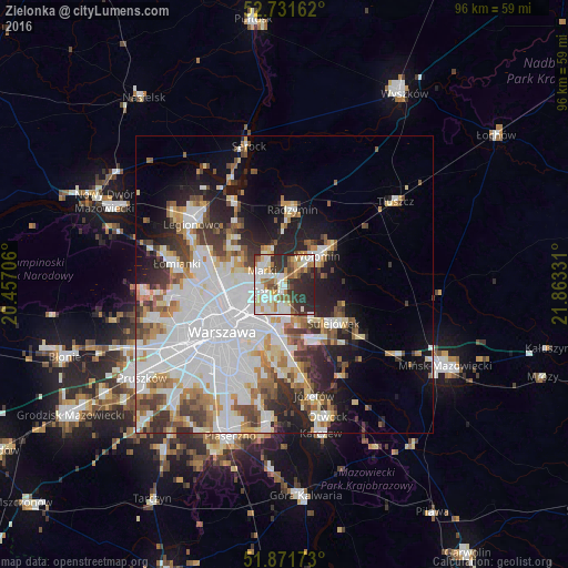
Analysis of Zielonka night lights 2016
Square area 10x10 km:
 15.91%
90-99
18.94%80-89
7.32%70-79
8.21%60-69
6.82%50-59
5.81%40-49
4.8%30-39
12.12%20-29
19.32%10-19
0.76%0-9
0%Square area 50x50 km:
13.24%90-99
8.22%80-89
3.19%70-79
3.45%60-69
3.55%50-59
3.45%40-49
3.54%30-39
4.08%20-29
5.97%10-19
8.92%0-9
42.41%Clear (daylight) street map image can be seen on geolist.org.
Map coordinates:
52° 43' 53.8" North, 20° 27' 25.4" East
52° 18' 13.5" North, 21° 9' 36.6" East
51° 52' 18.2" North, 21° 51' 47.9" East
Some cities around Zielonka sort by population:
• Praga Południe
8.3 km =5.2 mi,  217°
217°
• Targówek
7.7 km =4.8 mi,  260°
260°
• Wołomin
6.9 km =4.3 mi,  54°
54°
• Ząbki
3.9 km =2.4 mi,  251°
251°
• Marki
4.2 km =2.6 mi,  296°
296°
• Rembertów
4.8 km =3 mi,  177°
177°
• Wesoła
7 km =4.3 mi,  141°
141°
• Kobyłka
4.7 km =2.9 mi,  31°
31°
753276 (p: 17,518)
Sources (retrieved 2019-11-25):
» Earth at Night: Flat Maps 2012, 2016