Pułtusk night lights from space
Night Light of Pułtusk (Mazovia) from space (Poland) Src. Average luminocity for 10x10km area is 10.3981% and for 50x50km: 1.9739%.
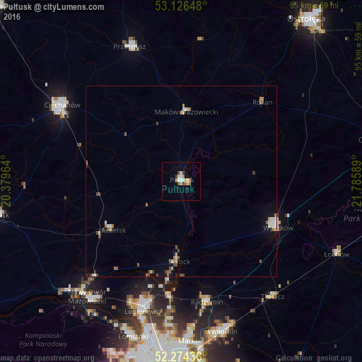
Analysis of Pułtusk night lights 2016
Square area 10x10 km:
 1.46%
1.46%90-99
2.78%80-89
0.66%70-79
1.46%60-69
1.59%50-59
0.53%40-49
0.79%30-39
1.32%20-29
0%10-19
1.19%0-9
88.23%Square area 50x50 km:
0.27%90-99
0.31%80-89
0.15%70-79
0.19%60-69
0.34%50-59
0.32%40-49
0.34%30-39
0.19%20-29
0.05%10-19
0.69%0-9
97.15%Clear (daylight) street map image can be seen on geolist.org.
Map coordinates:
53° 7' 35.3" North, 20° 22' 46.7" East
52° 42' 9" North, 21° 4' 57.9" East
52° 16' 27.7" North, 21° 47' 9.2" East
Some cities around Pułtusk sort by population:
• Legionowo
35.1 km =21.8 mi,  197°
197°
• Ciechanów
36.9 km =22.9 mi,  302°
302°
• Wyszków
28.1 km =17.5 mi,  115°
115°
• Przasnysz
37.7 km =23.4 mi,  338°
338°
• Maków Mazowiecki
18.1 km =11.2 mi,  3°
3°
• Radzymin
32.6 km =20.3 mi,  167°
167°
• Nasielsk
22.6 km =14 mi,  235°
235°
• Jabłonna
37.7 km =23.4 mi, 197°
760917 (p: 19,039)
Sources (retrieved 2019-11-25):
» Earth at Night: Flat Maps 2012, 2016