Nasielsk night lights from space
Night Light of Nasielsk (Mazovia) from space (Poland) Src. Average luminocity for 10x10km area is 5.3095% and for 50x50km: 6.3237%.
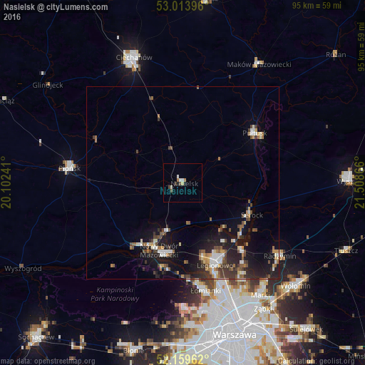
Analysis of Nasielsk night lights 2016
Square area 10x10 km:
 1.32%
1.32%90-99
0.79%80-89
0.53%70-79
0%60-69
1.06%50-59
0.53%40-49
1.46%30-39
0.13%20-29
0.26%10-19
0.26%0-9
93.65%Square area 50x50 km:
0.74%90-99
0.96%80-89
0.44%70-79
0.58%60-69
0.86%50-59
0.95%40-49
1.17%30-39
1.13%20-29
1.86%10-19
5.55%0-9
85.77%Clear (daylight) street map image can be seen on geolist.org.
Map coordinates:
53° 0' 50.3" North, 20° 6' 8.7" East
52° 35' 19.9" North, 20° 48' 19.9" East
52° 9' 34.6" North, 21° 30' 31.2" East
Some cities around Nasielsk sort by population:
• Białołeka
31.8 km =19.8 mi,  159°
159°
• Legionowo
22.4 km =13.9 mi, 158°
• Nowy Dwór Mazowiecki
18.6 km =11.6 mi,  198°
198°
• Płońsk
29.3 km =18.2 mi,  277°
277°
• Pułtusk
22.6 km =14 mi,  55°
55°
• Łomianki
28.8 km =17.9 mi,  169°
169°
• Radzymin
32 km =19.9 mi,  126°
126°
• Jabłonna
24.6 km =15.3 mi, 162°
764100 (p: 7,445)
Sources (retrieved 2019-11-25):
» Earth at Night: Flat Maps 2012, 2016