Pawłowice night lights from space
Night Light of Pawłowice (Silesia) from space (Poland) Src. Average luminocity for 10x10km area is 14.1541% and for 50x50km: 24.1487%.
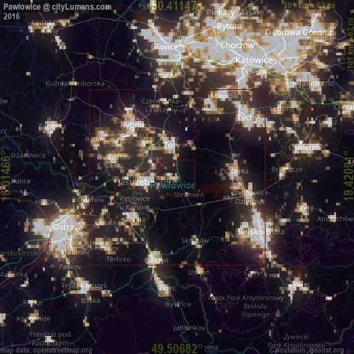
Analysis of Pawłowice night lights 2016
Square area 10x10 km:
 0.98%
0.98%90-99
1.26%80-89
0.56%70-79
1.96%60-69
1.26%50-59
1.54%40-49
3.36%30-39
1.68%20-29
4.62%10-19
23.39%0-9
59.38%Square area 50x50 km:
3.67%90-99
4.14%80-89
1.51%70-79
2.06%60-69
2.88%50-59
3.23%40-49
4.07%30-39
4.38%20-29
10.53%10-19
21.09%0-9
42.43%Clear (daylight) street map image can be seen on geolist.org.
Map coordinates:
50° 24' 41.3" North, 18° 0' 52.8" East
49° 57' 40.6" North, 18° 43' 4" East
49° 30' 24.6" North, 19° 25' 15.3" East
Some cities around Pawłowice sort by population:
• Jastrzębie Zdrój
10.2 km =6.3 mi,  266°
266°
• Karviná, CZ
17.4 km =10.8 mi,  226°
226°
• Żory
9.4 km =5.8 mi,  352°
352°
• Wodzisław Śląski
18.2 km =11.3 mi,  285°
285°
• Pszczyna
17 km =10.6 mi,  82°
82°
• Goczałkowice Zdrój
18.1 km =11.2 mi,  95°
95°
• Markłowice
15.4 km =9.6 mi, 293°
• Zebrzydowice
12 km =7.5 mi,  219°
219°
3089340 (p: 9,929)
Sources (retrieved 2019-11-25):
» Earth at Night: Flat Maps 2012, 2016