Goczałkowice Zdrój night lights from space
Night Light of Goczałkowice Zdrój (Silesia) from space (Poland) Src. Average luminocity for 10x10km area is 36.6779% and for 50x50km: 20.543%.
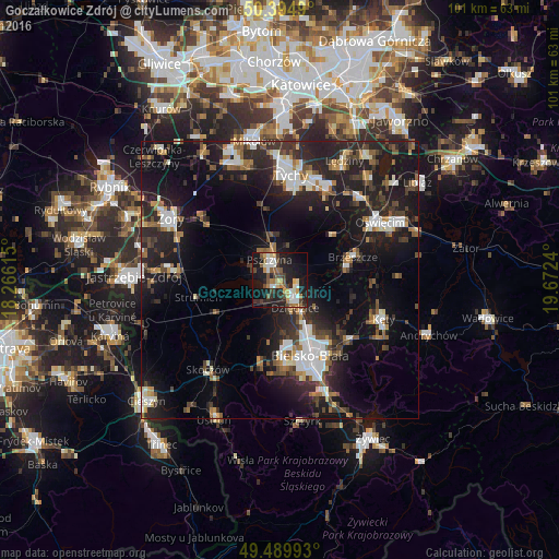
Analysis of Goczałkowice Zdrój night lights 2016
Square area 10x10 km:
 5.18%
5.18%90-99
6.58%80-89
4.34%70-79
3.08%60-69
5.18%50-59
5.04%40-49
6.58%30-39
5.88%20-29
13.03%10-19
31.09%0-9
14.01%Square area 50x50 km:
3.1%90-99
3.53%80-89
1.15%70-79
1.67%60-69
2.41%50-59
2.68%40-49
3.08%30-39
3.82%20-29
8.53%10-19
18.7%0-9
51.33%Clear (daylight) street map image can be seen on geolist.org.
Map coordinates:
50° 23' 41.6" North, 18° 15' 58.1" East
49° 56' 40.3" North, 18° 58' 9.4" East
49° 29' 23.7" North, 19° 40' 20.6" East
Some cities around Goczałkowice Zdrój sort by population:
• Bielsko-Biala
14.7 km =9.1 mi,  157°
157°
• Czechowice-Dziedzice
4.3 km =2.7 mi,  143°
143°
• Pszczyna
4.1 km =2.5 mi,  344°
344°
• Kozy
16.8 km =10.4 mi,  129°
129°
• Brzeszcze
13.7 km =8.5 mi,  72°
72°
• Pawłowice
18.1 km =11.2 mi,  275°
275°
• Wola
13.7 km =8.5 mi,  53°
53°
• Jaworze
16.9 km =10.5 mi,  185°
185°
3099095 (p: 6,321)
Sources (retrieved 2019-11-25):
» Earth at Night: Flat Maps 2012, 2016