Markłowice night lights from space
Night Light of Markłowice (Silesia) from space (Poland) Src. Average luminocity for 10x10km area is 42.2339% and for 50x50km: 21.6669%.
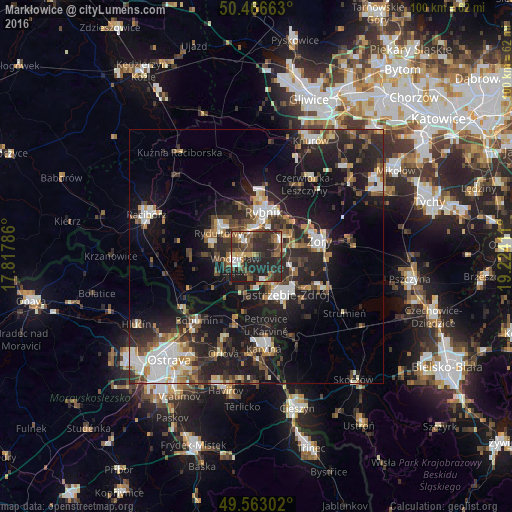
Analysis of Markłowice night lights 2016
Square area 10x10 km:
 4.76%
4.76%90-99
4.2%80-89
3.78%70-79
2.94%60-69
5.04%50-59
9.8%40-49
13.45%30-39
8.68%20-29
40.34%10-19
7%0-9
0%Square area 50x50 km:
3.44%90-99
3.5%80-89
1.39%70-79
2.17%60-69
2.57%50-59
2.75%40-49
3.86%30-39
3.83%20-29
9.6%10-19
17.32%0-9
49.57%Clear (daylight) street map image can be seen on geolist.org.
Map coordinates:
50° 27' 59.9" North, 17° 49' 4.3" East
50° 1' 1" North, 18° 31' 15.5" East
49° 33' 46.9" North, 19° 13' 26.8" East
Some cities around Markłowice sort by population:
• Rybnik
9 km =5.6 mi,  9°
9°
• Jastrzębie Zdrój
7.8 km =4.8 mi,  150°
150°
• Żory
13.2 km =8.2 mi,  76°
76°
• Wodzisław Śląski
3.8 km =2.4 mi,  247°
247°
• Rydułtowy
8.7 km =5.4 mi,  301°
301°
• Radlin
4.9 km =3 mi,  319°
319°
• Pszów
9.4 km =5.8 mi,  285°
285°
• Niedobczyce
5.7 km =3.5 mi,  341°
341°
3092276 (p: 5,173)
Sources (retrieved 2019-11-25):
» Earth at Night: Flat Maps 2012, 2016