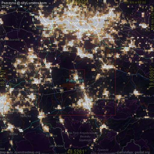
Pszczyna night lights from space
Night Light of Pszczyna (Silesia) from space (Poland) Src. Average luminocity for 10x10km area is 28.3361% and for 50x50km: 23.1094%.

Analysis of Pszczyna night lights 2016
Square area 10x10 km:
 2.94%
2.94%90-99
3.22%80-89
3.5%70-79
1.82%60-69
6.02%50-59
5.18%40-49
6.3%30-39
4.48%20-29
6.02%10-19
29.69%0-9
30.81%Square area 50x50 km:
3.52%90-99
4.04%80-89
1.27%70-79
2.04%60-69
2.74%50-59
3.05%40-49
3.45%30-39
4.62%20-29
10.24%10-19
19.26%0-9
45.77%Clear (daylight) street map image can be seen on geolist.org.
Map coordinates:
50° 25' 49.4" North, 18° 15' 2.5" East
49° 58' 49.3" North, 18° 57' 13.8" East
49° 31' 34" North, 19° 39' 25" East
Some cities around Pszczyna sort by population:
• Bielsko-Biala
18.8 km =11.7 mi,  159°
159°
• Tychy
17.5 km =10.9 mi,  2°
2°
• Czechowice-Dziedzice
8.3 km =5.2 mi,  153°
153°
• Bieruń
15.7 km =9.8 mi,  39°
39°
• Brzeszcze
14.1 km =8.8 mi,  89°
89°
• Pawłowice
17 km =10.6 mi,  262°
262°
• Wola
12.8 km =8 mi,  71°
71°
• Goczałkowice Zdrój
4.1 km =2.5 mi, 164°
3087705 (p: 25,288)
Sources (retrieved 2019-11-25):
» Earth at Night: Flat Maps 2012, 2016