Niemodlin night lights from space
Night Light of Niemodlin (Opole Voivodeship) from space (Poland) Src. Average luminocity for 10x10km area is 4.7968% and for 50x50km: 5.4035%.
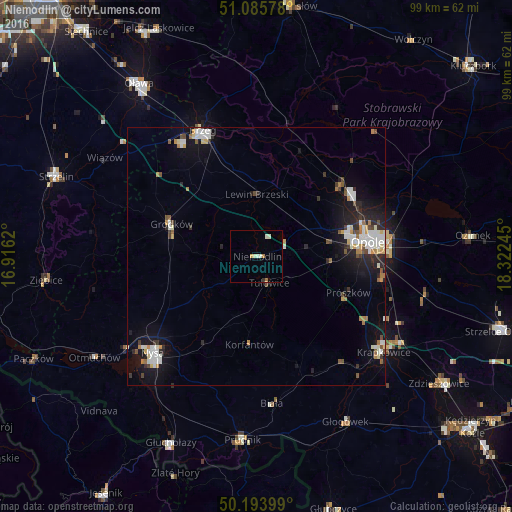
Analysis of Niemodlin night lights 2016
Square area 10x10 km:
 0%
0%90-99
2.41%80-89
0.67%70-79
0.13%60-69
1.07%50-59
0%40-49
0%30-39
0.53%20-29
0%10-19
0.53%0-9
94.65%Square area 50x50 km:
1.01%90-99
1.14%80-89
0.4%70-79
0.47%60-69
0.57%50-59
0.44%40-49
0.58%30-39
0.49%20-29
1.44%10-19
4.04%0-9
89.43%Clear (daylight) street map image can be seen on geolist.org.
Map coordinates:
51° 5' 8.8" North, 16° 54' 58.3" East
50° 38' 31.2" North, 17° 37' 9.6" East
50° 11' 38.4" North, 18° 19' 20.8" East
Some cities around Niemodlin sort by population:
• Opole
21.8 km =13.5 mi,  81°
81°
• Nysa
27.5 km =17.1 mi,  227°
227°
• Brzeg
26.6 km =16.5 mi,  336°
336°
• Prudnik
35.8 km =22.2 mi,  185°
185°
• Krapkowice
30.7 km =19.1 mi,  127°
127°
• Grodków
17.7 km =11 mi,  290°
290°
• Gogolin
32.8 km =20.4 mi,  120°
120°
• Lewin Brzeski
11.9 km =7.4 mi,  359°
359°
3090951 (p: 6,828)
Sources (retrieved 2019-11-25):
» Earth at Night: Flat Maps 2012, 2016