Myślibórz night lights from space
Night Light of Myślibórz (West Pomerania) from space (Poland) Src. Average luminocity for 10x10km area is 3.2646% and for 50x50km: 2.0511%.
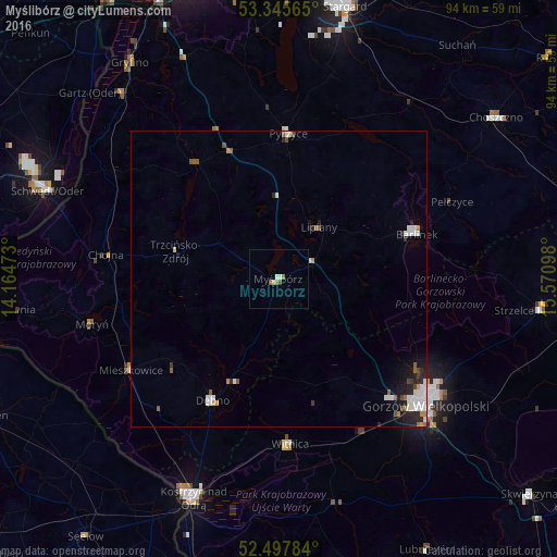
Analysis of Myślibórz night lights 2016
Square area 10x10 km:
 0.26%
0.26%90-99
0.79%80-89
0.53%70-79
0.13%60-69
0.79%50-59
0.66%40-49
0.53%30-39
0%20-29
0%10-19
0%0-9
96.3%Square area 50x50 km:
0.49%90-99
0.48%80-89
0.11%70-79
0.13%60-69
0.15%50-59
0.34%40-49
0.21%30-39
0.11%20-29
0.52%10-19
0.81%0-9
96.64%Clear (daylight) street map image can be seen on geolist.org.
Map coordinates:
53° 20' 44.3" North, 14° 9' 53" East
52° 55' 25.8" North, 14° 52' 4.3" East
52° 29' 52.2" North, 15° 34' 15.5" East
Some cities around Myślibórz sort by population:
• Gorzów Wielkopolski
31.9 km =19.8 mi,  130°
130°
• Schwedt (Oder), DE
42 km =26.1 mi,  291°
291°
• Kostrzyn nad Odrą
40.2 km =25 mi,  201°
201°
• Barlinek
24.8 km =15.4 mi,  71°
71°
• Dębno
23.5 km =14.6 mi,  209°
209°
• Pyrzyce
24.8 km =15.4 mi,  3°
3°
• Chojna
29.8 km =18.5 mi,  278°
278°
• Witnica
27.9 km =17.3 mi,  175°
175°
3091253 (p: 12,092)
Sources (retrieved 2019-11-25):
» Earth at Night: Flat Maps 2012, 2016