Dębno night lights from space
Night Light of Dębno (West Pomerania) from space (Poland) Src. Average luminocity for 10x10km area is 5.9975% and for 50x50km: 1.4826%.
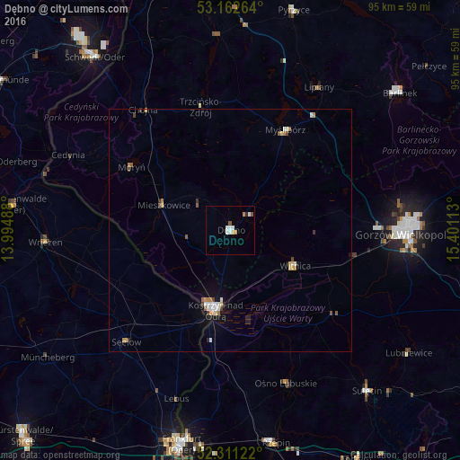
Analysis of Dębno night lights 2016
Square area 10x10 km:
 1.64%
1.64%90-99
1.39%80-89
0.51%70-79
1.01%60-69
0%50-59
1.01%40-49
0%30-39
0%20-29
0.51%10-19
0%0-9
93.94%Square area 50x50 km:
0.22%90-99
0.25%80-89
0.19%70-79
0.19%60-69
0.18%50-59
0.16%40-49
0.18%30-39
0.09%20-29
0.17%10-19
0.61%0-9
97.74%Clear (daylight) street map image can be seen on geolist.org.
Map coordinates:
53° 9' 45.5" North, 13° 59' 41.6" East
52° 44' 20.4" North, 14° 41' 52.8" East
52° 18' 40.4" North, 15° 24' 4.1" East
Some cities around Dębno sort by population:
• Gorzów Wielkopolski
35.7 km =22.2 mi,  90°
90°
• Kostrzyn nad Odrą
17.2 km =10.7 mi,  190°
190°
• Myślibórz
23.5 km =14.6 mi,  29°
29°
• Sulęcin
43.3 km =26.9 mi,  139°
139°
• Wriezen, DE
38 km =23.6 mi,  266°
266°
• Chojna
30.9 km =19.2 mi,  324°
324°
• Witnica
15.3 km =9.5 mi,  118°
118°
• Seelow, DE
31.3 km =19.4 mi,  223°
223°
3100545 (p: 13,804)
Sources (retrieved 2019-11-25):
» Earth at Night: Flat Maps 2012, 2016