Kostrzyn nad Odrą night lights from space
Night Light of Kostrzyn nad Odrą (Lubusz) from space (Poland) Src. Average luminocity for 10x10km area is 15.3519% and for 50x50km: 1.4963%.
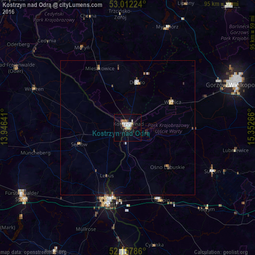
Analysis of Kostrzyn nad Odrą night lights 2016
Square area 10x10 km:
 2.91%
2.91%90-99
3.44%80-89
1.59%70-79
0.93%60-69
2.51%50-59
0.26%40-49
1.85%30-39
0.26%20-29
0.93%10-19
12.43%0-9
72.88%Square area 50x50 km:
0.2%90-99
0.22%80-89
0.17%70-79
0.19%60-69
0.15%50-59
0.12%40-49
0.18%30-39
0.07%20-29
0.23%10-19
1.1%0-9
97.36%Clear (daylight) street map image can be seen on geolist.org.
Map coordinates:
53° 0' 44.1" North, 13° 56' 47.1" East
52° 35' 13.7" North, 14° 38' 58.3" East
52° 9' 28.3" North, 15° 21' 9.6" East
Some cities around Kostrzyn nad Odrą sort by population:
• Frankfurt (Oder), DE
27.5 km =17.1 mi,  194°
194°
• Słubice
26.9 km =16.7 mi, 192°
• Dębno
17.2 km =10.7 mi,  10°
10°
• Sulęcin
35.4 km =22 mi,  116°
116°
• Müncheberg, DE
35.8 km =22.2 mi,  255°
255°
• Witnica
19.3 km =12 mi,  60°
60°
• Rzepin
29.5 km =18.3 mi,  155°
155°
• Seelow, DE
19.1 km =11.9 mi,  251°
251°
3095057 (p: 18,099)
Sources (retrieved 2019-11-25):
» Earth at Night: Flat Maps 2012, 2016