Barlinek night lights from space
Night Light of Barlinek (West Pomerania) from space (Poland) Src. Average luminocity for 10x10km area is 6.328% and for 50x50km: 1.165%.
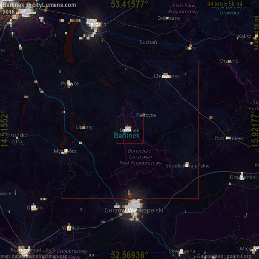
Analysis of Barlinek night lights 2016
Square area 10x10 km:
 1.72%
1.72%90-99
2.51%80-89
0%70-79
0.13%60-69
0.4%50-59
0%40-49
0%30-39
0.4%20-29
1.19%10-19
0%0-9
93.65%Square area 50x50 km:
0.2%90-99
0.24%80-89
0.06%70-79
0.09%60-69
0.1%50-59
0.15%40-49
0.12%30-39
0.09%20-29
0.25%10-19
0.59%0-9
98.09%Clear (daylight) street map image can be seen on geolist.org.
Map coordinates:
53° 24' 56.8" North, 14° 30' 55.9" East
52° 59' 40.7" North, 15° 13' 7.1" East
52° 34' 9.7" North, 15° 55' 18.4" East
Some cities around Barlinek sort by population:
• Gorzów Wielkopolski
28.7 km =17.8 mi,  178°
178°
• Stargard
39.7 km =24.7 mi,  343°
343°
• Choszczno
23.6 km =14.7 mi,  34°
34°
• Pyrzyce
27.5 km =17.1 mi,  307°
307°
• Myślibórz
24.8 km =15.4 mi,  251°
251°
• Drezdenko
44.6 km =27.7 mi,  112°
112°
• Strzelce Krajeńskie
24.6 km =15.3 mi,  122°
122°
• Witnica
41.7 km =25.9 mi,  211°
211°
3103824 (p: 14,385)
Sources (retrieved 2019-11-25):
» Earth at Night: Flat Maps 2012, 2016