Brzeszcze night lights from space
Night Light of Brzeszcze (Lesser Poland) from space (Poland) Src. Average luminocity for 10x10km area is 15.8431% and for 50x50km: 21.4685%.
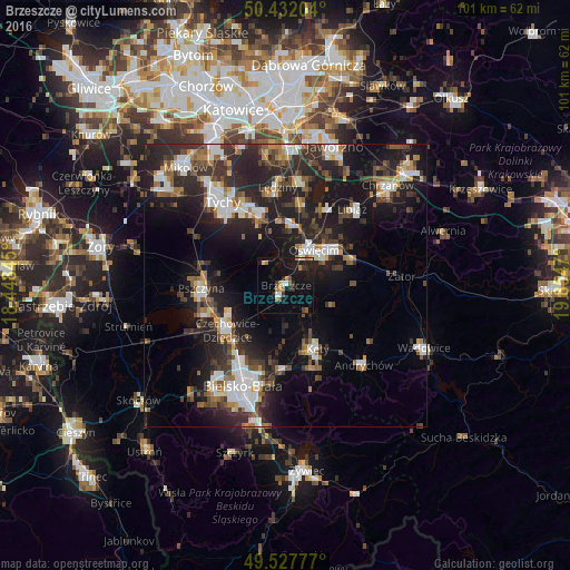
Analysis of Brzeszcze night lights 2016
Square area 10x10 km:
 0.98%
0.98%90-99
1.54%80-89
0.98%70-79
1.96%60-69
3.08%50-59
1.82%40-49
0.98%30-39
2.66%20-29
3.78%10-19
21.29%0-9
60.92%Square area 50x50 km:
3.44%90-99
3.84%80-89
1.21%70-79
1.82%60-69
2.64%50-59
2.84%40-49
3.29%30-39
4.37%20-29
9.12%10-19
16.89%0-9
50.54%Clear (daylight) street map image can be seen on geolist.org.
Map coordinates:
50° 25' 55.3" North, 18° 26' 54.4" East
49° 58' 55.3" North, 19° 9' 5.7" East
49° 31' 40" North, 19° 51' 16.9" East
Some cities around Brzeszcze sort by population:
• Oświęcim
7.2 km =4.5 mi,  35°
35°
• Czechowice-Dziedzice
13 km =8.1 mi,  234°
234°
• Pszczyna
14.1 km =8.8 mi,  269°
269°
• Bieruń
12.7 km =7.9 mi,  340°
340°
• Kęty
12.2 km =7.6 mi,  155°
155°
• Wola
4.4 km =2.7 mi,  332°
332°
• Osiek
8.8 km =5.5 mi,  113°
113°
• Goczałkowice Zdrój
13.7 km =8.5 mi,  252°
252°
3102444 (p: 11,787)
Sources (retrieved 2019-11-25):
» Earth at Night: Flat Maps 2012, 2016