Kęty night lights from space
Night Light of Kęty (Lesser Poland) from space (Poland) Src. Average luminocity for 10x10km area is 18.9272% and for 50x50km: 14.1438%.
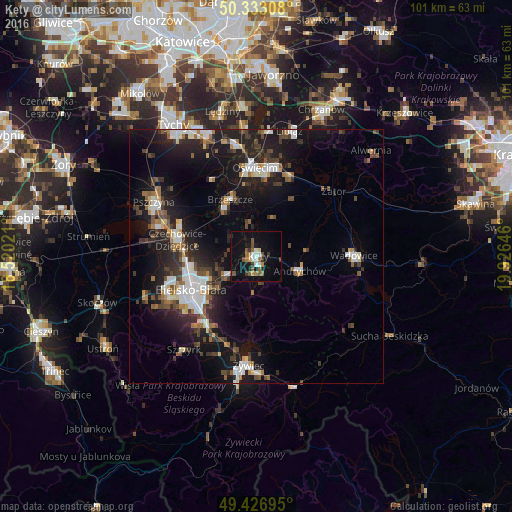
Analysis of Kęty night lights 2016
Square area 10x10 km:
 1.68%
1.68%90-99
2.8%80-89
0.98%70-79
1.4%60-69
2.8%50-59
5.74%40-49
1.96%30-39
2.52%20-29
1.26%10-19
18.91%0-9
59.94%Square area 50x50 km:
2.4%90-99
2.43%80-89
0.78%70-79
0.91%60-69
1.65%50-59
1.77%40-49
2.29%30-39
2.65%20-29
4.22%10-19
12.96%0-9
67.94%Clear (daylight) street map image can be seen on geolist.org.
Map coordinates:
50° 19' 59.1" North, 18° 31' 12.8" East
49° 52' 55.7" North, 19° 13' 24" East
49° 25' 37" North, 19° 55' 35.3" East
Some cities around Kęty sort by population:
• Bielsko-Biala
14.3 km =8.9 mi,  242°
242°
• Czechowice-Dziedzice
16 km =9.9 mi,  282°
282°
• Andrychów
8.8 km =5.5 mi,  110°
110°
• Kozy
6.6 km =4.1 mi,  234°
234°
• Brzeszcze
12.2 km =7.6 mi,  335°
335°
• Osiek
8.2 km =5.1 mi,  21°
21°
• Czaniec
4.1 km =2.5 mi,  148°
148°
• Wieprz
9.6 km =6 mi,  84°
84°
3096328 (p: 19,249)
Sources (retrieved 2019-11-25):
» Earth at Night: Flat Maps 2012, 2016