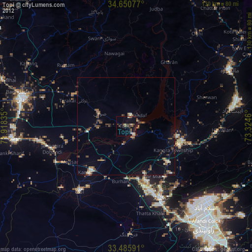
Topi night lights from space
Night Light of Topi (Khyber Pakhtunkhwa) from space (Pakistan) Src. Average luminocity for 10x10km area is 20.6766% and for 50x50km: 6.087%.

Analysis of Topi night lights 2016
Square area 10x10 km:
 0%
0%90-99
2.62%80-89
2.45%70-79
4.72%60-69
3.5%50-59
1.05%40-49
5.24%30-39
3.15%20-29
2.1%10-19
27.97%0-9
47.2%Square area 50x50 km:
0.26%90-99
1.05%80-89
0.4%70-79
0.52%60-69
0.72%50-59
0.78%40-49
1.47%30-39
1.1%20-29
1.47%10-19
6.83%0-9
85.4%Clear (daylight) street map image can be seen on geolist.org.
Map coordinates:
34° 39' 2.8" North, 71° 55' 6.1" East
34° 4' 13.2" North, 72° 37' 17.3" East
33° 29' 9.3" North, 73° 19' 28.6" East
Some cities around Topi sort by population:
• Swabi
15 km =9.3 mi,  291°
291°
• Attock City
41.5 km =25.8 mi,  215°
215°
• Haripur
30 km =18.6 mi,  105°
105°
• Khalabat
24.7 km =15.3 mi,  92°
92°
• Zaida
14.3 km =8.9 mi,  265°
265°
• Hazro City
21.5 km =13.4 mi,  213°
213°
• Akora
46.3 km =28.8 mi,  260°
260°
• Sanjwal
38.5 km =23.9 mi, 206°
1163224 (p: 36,340)
Sources (retrieved 2019-11-25):
» Earth at Night: Flat Maps 2012, 2016