Hazro City night lights from space
Night Light of Hazro City (Punjab) from space (Pakistan) Src. Average luminocity for 10x10km area is 11.3741% and for 50x50km: 10.8731%.

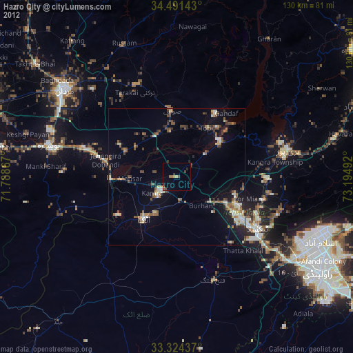
Analysis of Hazro City night lights 2016
Square area 10x10 km:
 0%
0%90-99
0.7%80-89
0%70-79
1.05%60-69
2.1%50-59
2.1%40-49
3.85%30-39
2.1%20-29
3.5%10-19
13.64%0-9
70.98%Square area 50x50 km:
0.44%90-99
2.19%80-89
1.16%70-79
1.03%60-69
1.2%50-59
1.7%40-49
2.39%30-39
1.84%20-29
3.21%10-19
8.71%0-9
76.13%Clear (daylight) street map image can be seen on geolist.org.
Map coordinates:
34° 29' 29.1" North, 71° 47' 19.2" East
33° 54' 35.6" North, 72° 29' 30.4" East
33° 19' 27.7" North, 73° 11' 41.7" East
Some cities around Hazro City sort by population:
• Swabi
23.5 km =14.6 mi,  355°
355°
• Attock City
20.1 km =12.5 mi,  217°
217°
• Haripur
42 km =26.1 mi,  76°
76°
• Khalabat
40.3 km =25 mi,  65°
65°
• Topi
21.5 km =13.4 mi,  33°
33°
• Zaida
16.8 km =10.4 mi,  352°
352°
• Akora
35.3 km =21.9 mi,  287°
287°
• Sanjwal
17.4 km =10.8 mi,  198°
198°
1176948 (p: 26,309)
Sources (retrieved 2019-11-25):
» Earth at Night: Flat Maps 2012, 2016