Sohbatpur night lights from space
Night Light of Sohbatpur (Balochistan) from space (Pakistan) Src. Average luminocity for 10x10km area is 0.8869% and for 50x50km: 1.139%.
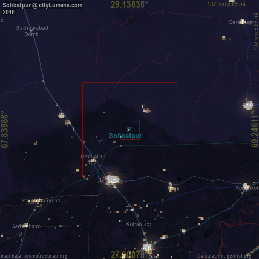
Analysis of Sohbatpur night lights 2016
Square area 10x10 km:
 0%
0%90-99
0%80-89
0%70-79
0%60-69
0.79%50-59
0%40-49
0.79%30-39
0%20-29
0%10-19
0%0-9
98.41%Square area 50x50 km:
0.05%90-99
0.18%80-89
0.11%70-79
0.04%60-69
0.04%50-59
0.11%40-49
0.33%30-39
0.41%20-29
0.27%10-19
0.87%0-9
97.57%Clear (daylight) street map image can be seen on geolist.org.
Map coordinates:
29° 8' 10.9" North, 67° 50' 23.5" East
28° 31' 13.4" North, 68° 32' 34.7" East
27° 54' 2.8" North, 69° 14' 46" East
Some cities around Sohbatpur sort by population:
• Jacobabad
28.5 km =17.7 mi,  201°
201°
• Shikarpur
63.5 km =39.5 mi,  171°
171°
• Usta Muhammad
62 km =38.5 mi,  232°
232°
• Thul
38.6 km =24 mi,  143°
143°
• Ghauspur
67.7 km =42.1 mi,  128°
128°
• Garhiyasin
68.3 km =42.4 mi,  182°
182°
• Tangwani
51.9 km =32.2 mi,  121°
121°
• Rustam
66.6 km =41.4 mi,  157°
157°
1164660 (p: 8,940)
Sources (retrieved 2019-11-25):
» Earth at Night: Flat Maps 2012, 2016