Gadani night lights from space
Night Light of Gadani (Balochistan) from space (Pakistan) Src. Average luminocity for 10x10km area is 5.2992% and for 50x50km: 8.0813%.
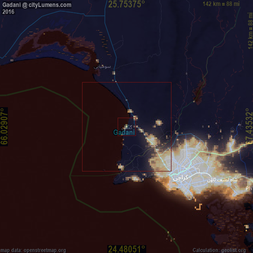
Analysis of Gadani night lights 2016
Square area 10x10 km:
 0%
0%90-99
0%80-89
0.38%70-79
0.76%60-69
0.76%50-59
0.57%40-49
2.84%30-39
0.95%20-29
3.22%10-19
0%0-9
90.53%Square area 50x50 km:
0.56%90-99
0.89%80-89
2.28%70-79
1.76%60-69
0.84%50-59
1.03%40-49
1.17%30-39
0.97%20-29
1.86%10-19
3.79%0-9
84.85%Clear (daylight) street map image can be seen on geolist.org.
Map coordinates:
25° 45' 13.5" North, 66° 1' 44.7" East
25° 7' 7.6" North, 66° 43' 55.9" East
24° 28' 49.8" North, 67° 26' 7.2" East
Some cities around Gadani sort by population:
• Karachi
40.1 km =24.9 mi,  135°
135°
• Malir Cantonment
51.6 km =32.1 mi,  112°
112°
• Thatta
127 km =78.9 mi, 108°
• Bela
130.2 km =80.9 mi,  341°
341°
• Gharo
95.7 km =59.5 mi,  115°
115°
• Uthal
77.3 km =48 mi,  351°
351°
• Daromehar
150.3 km =93.4 mi,  103°
103°
• Mirpur Sakro
110.5 km =68.7 mi,  125°
125°
1179185 (p: 13,427)
Sources (retrieved 2019-11-25):
» Earth at Night: Flat Maps 2012, 2016