Dijkot night lights from space
Night Light of Dijkot (Punjab) from space (Pakistan) Src. Average luminocity for 10x10km area is 1.956% and for 50x50km: 9.5939%.
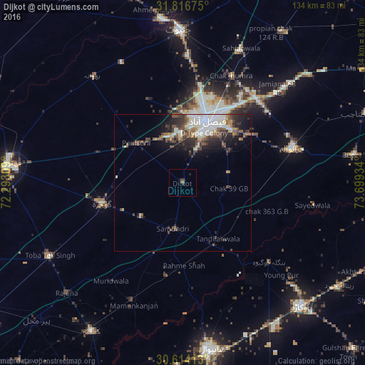
Analysis of Dijkot night lights 2016
Square area 10x10 km:
 0%
0%90-99
0%80-89
0%70-79
0%60-69
0%50-59
1.47%40-49
0%30-39
1.47%20-29
1.47%10-19
0.73%0-9
94.87%Square area 50x50 km:
1.22%90-99
2.93%80-89
0.77%70-79
0.5%60-69
0.82%50-59
1.76%40-49
1.89%30-39
1.64%20-29
2.54%10-19
4.22%0-9
81.72%Clear (daylight) street map image can be seen on geolist.org.
Map coordinates:
31° 49' 0.3" North, 72° 17' 35.1" East
31° 13' 2.5" North, 72° 59' 46.4" East
30° 36' 50.9" North, 73° 41' 57.6" East
Some cities around Dijkot sort by population:
• Faisalabad
23.8 km =14.8 mi,  21°
21°
• Gojra
30.7 km =19.1 mi,  255°
255°
• Jaranwala
42.2 km =26.2 mi,  72°
72°
• Tandlianwala
24.2 km =15 mi,  147°
147°
• Chak Jhumra
42.8 km =26.6 mi, 24°
• Khurrianwala
40.6 km =25.2 mi,  39°
39°
• Mamu Kanjan
46.9 km =29.1 mi,  203°
203°
• Bhawana
51.1 km =31.8 mi,  319°
319°
1179834 (p: 27,469)
Sources (retrieved 2019-11-25):
» Earth at Night: Flat Maps 2012, 2016