Santo Cristo night lights from space
Night Light of Santo Cristo (Central Luzon) from space (Philippines) Src. Average luminocity for 10x10km area is 9.6054% and for 50x50km: 4.4261%.
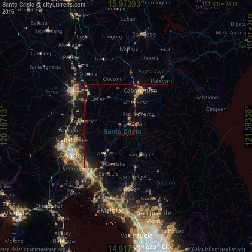
Analysis of Santo Cristo night lights 2016
Square area 10x10 km:
 0%
0%90-99
0%80-89
0.41%70-79
2.27%60-69
2.69%50-59
0%40-49
3.31%30-39
2.89%20-29
4.13%10-19
4.75%0-9
79.55%Square area 50x50 km:
0%90-99
0.03%80-89
0.34%70-79
1.07%60-69
0.98%50-59
0.39%40-49
1.05%30-39
1.16%20-29
1.42%10-19
3.75%0-9
89.82%Clear (daylight) street map image can be seen on geolist.org.
Map coordinates:
15° 58' 26.1" North, 120° 11' 13.7" East
15° 17' 48.6" North, 120° 53' 24.9" East
14° 37' 3.1" North, 121° 35' 36.2" East
Some cities around Santo Cristo sort by population:
• Gapan
6.1 km =3.8 mi,  79°
79°
• Cabiao
6.6 km =4.1 mi,  215°
215°
• Jaen
4.6 km =2.9 mi,  42°
42°
• Papaya
6.4 km =4 mi,  293°
293°
• San Antonio
3.8 km =2.4 mi, 285°
• Pulo
7 km =4.3 mi,  144°
144°
• San Mariano
3.1 km =1.9 mi,  330°
330°
• Entablado
3.1 km =1.9 mi,  248°
248°
1687753 (p: 8,664)
Sources (retrieved 2019-11-25):
» Earth at Night: Flat Maps 2012, 2016