Pulo night lights from space
Night Light of Pulo (Central Luzon) from space (Philippines) Src. Average luminocity for 10x10km area is 1.1983% and for 50x50km: 3.3355%.
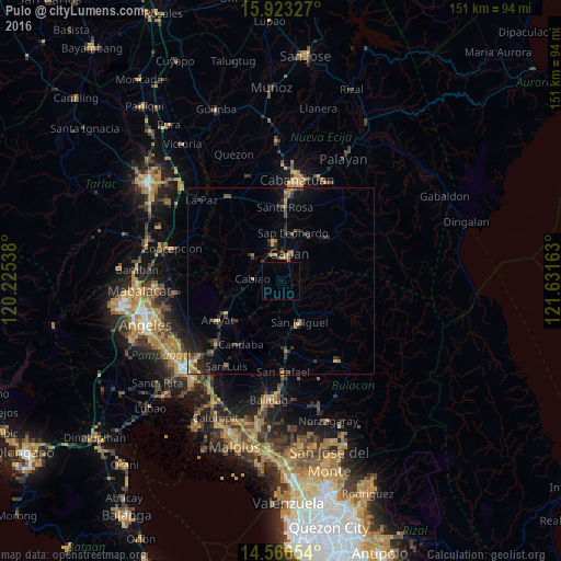
Analysis of Pulo night lights 2016
Square area 10x10 km:
 0%
0%90-99
0%80-89
0%70-79
0%60-69
0%50-59
0.21%40-49
0.41%30-39
0%20-29
0%10-19
0.83%0-9
98.55%Square area 50x50 km:
0.03%90-99
0.07%80-89
0.2%70-79
0.62%60-69
0.61%50-59
0.41%40-49
0.79%30-39
1.19%20-29
1.27%10-19
2.35%0-9
92.46%Clear (daylight) street map image can be seen on geolist.org.
Map coordinates:
15° 55' 23.8" North, 120° 13' 31.4" East
15° 14' 45.6" North, 120° 55' 42.6" East
14° 33' 59.5" North, 121° 37' 53.9" East
Some cities around Pulo sort by population:
• Gapan
7.1 km =4.4 mi,  15°
15°
• Cabiao
7.9 km =4.9 mi,  272°
272°
• Jaen
9.1 km =5.7 mi,  353°
353°
• Santo Cristo
7 km =4.3 mi,  324°
324°
• Nieves
9.4 km =5.8 mi,  13°
13°
• Camias
10.1 km =6.3 mi,  150°
150°
• San Mariano
10 km =6.2 mi,  325°
325°
• Entablado
8.3 km =5.2 mi,  302°
302°
1692549 (p: 10,776)
Sources (retrieved 2019-11-25):
» Earth at Night: Flat Maps 2012, 2016